Data Sets » Format: rasterRemove Facet
7 of 9

Global Cyclone Total Economic Loss Risk Deciles, v1 (2000)

Natural Disaster Hotspots

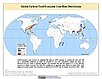
To provide a spatial surface of the total economic impacts of global cyclone hazard.

Global Cyclone Proportional Economic Loss Risk Deciles, v1 (2000)

Natural Disaster Hotspots

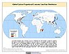
To provide a spatial surface of the proportional economic impacts of global cyclone hazard.

Global Earthquake Mortality Risks and Distribution, v1 (2000)

Natural Disaster Hotspots

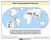
To provide a means of assessing global earthquake mortality risks and distribution.

Global Flood Proportional Economic Loss Risk Deciles, v1 (2000)

Natural Disaster Hotspots

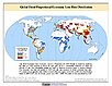
To provide a spatial surface of the proportional economic impacts of global flood hazard.

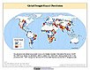
Global Flood Mortality Risks and Distribution, v1 (2000)

Natural Disaster Hotspots

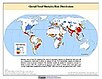
To provide a means of assessing global flood mortality risks and distribution.

Global Earthquake Total Economic Loss Risk Deciles, v1 (2000)

Natural Disaster Hotspots

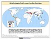
To provide a spatial surface of the total economic impacts of global earthquake hazard.

Global Drought Hazard Frequency and Distribution, v1 (1980 – 2000)

Natural Disaster Hotspots

To provide a means of assessing the relative distribution and frequency of global drought hazard.

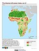
Global Human Influence Index (Geographic), v2 (1995 – 2004)

Last of the Wild, v2

To provide an updated map of anthropogenic impacts on the environment in geographic projection which can be used in wildlife conservation planning, natural resource management, and research on human-environment interactions.

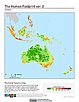
Global Human Footprint (IGHP), v2 (1995 – 2004)

Last of the Wild, v2

To provide an updated map of anthropogenic impacts on the environment in Interrupted Goode Homolosine Projection which can be used in wildlife conservation planning, natural resource management, and research on human-environment interactions.

Global Human Influence Index (IGHP), v2 (1995 – 2004)

Last of the Wild, v2

To provide an updated map of anthropogenic impacts on the environment in the Interrupted Goode Homolosine Projection which can be used in wildlife conservation planning, natural resource management, and research on human-environment interactions.

Global Human Footprint (Geographic), v2 (1995 – 2004)

Last of the Wild, v2

To provide an updated map of anthropogenic impacts on the environment in geographic projection which can be used in wildlife conservation planning, natural resource management, and research on human-environment interactions.

MA Climate and Land Cover, v1 (1901 – 2000)

Millennium Ecosystem Assessment (MA)

To preserve access to the original climate and land cover data used by the Millennium Ecosystem Assessment (MA) and other related research.

MA Ecosystems, v1 (2000)

Millennium Ecosystem Assessment (MA)

To preserve access to the original ecosystems data used by the Millennium Ecosystem Assessment (MA) and other related research.

MA Population, v1 (1990 – 2002)

Millennium Ecosystem Assessment (MA)

To preserve access to the original population data used by the Millennium Ecosystem Assessment (MA) and other related research.

MA Rapid Land Cover Change, v1 (1901 – 2015)

Millennium Ecosystem Assessment (MA)

To preserve access to the original rapid land cover change data used by the Millennium Ecosystem Assessment (MA) and other related research.

Global Subnational Prevalence of Child Malnutrition, v1 (1990 – 2002)

Poverty Mapping

To provide a global subnational map of the prevalence of underweight children that can be used by a wide user community in interdisciplinary studies of health, poverty and the environment.

Global Subnational Infant Mortality Rates, v1 (2000)

Poverty Mapping

To provide a global subnational map of infant mortality rate estimates that can be used by a wide user community in interdisciplinary studies of health, poverty and the environment.

MA Biodiversity, v1 (1950 – 2001)

Millennium Ecosystem Assessment (MA)

To preserve access to the original biodiversity data used by the Millennium Ecosystem Assessment (MA) and other related research.

MA Scenarios, v1 (1995 – 2100)

Millennium Ecosystem Assessment (MA)

To preserve access to the original set of socioeconomic and natural resource scenarios used by the Millennium Ecosystem Assessment (MA) and other related research.

Global Mangrove Forests Distribution, v1 (2000)

Land Use and Land Cover

To provide data that can be used in global mangrove forest distribution modeling, land cover change analysis, global carbon accounting studies and to assist with policy-making in regards to human-environment interactions and future adaptive strategies.

Data Sets » Format: rasterRemove Facet
7 of 9