Search » Data Sets (300)
| 3 of 15 |
Global High Resolution Daily Extreme Urban Heat Exposure (UHE-Daily), v1 (
|
Global Subnational Infant Mortality Rates, v2.01 (2015)Poverty Mapping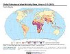
To provide a global subnational map of infant mortality rate estimates for the year 2015, to be used by a wide user community in interdisciplinary studies of health, poverty, and the environment. |
|
SSPs Literature Database, v1 (
|
Georeferenced U.S. County-Level Population Projections, Total and by Sex, Race and Age, Based on the SSPs, v1 (
|
|
Natural Resource Protection and Child Health Indicators, 2021 Release (
|
Urban-Rural Population and Land Area Estimates, v3 (1990, 2000, 2015)Low Elevation Coastal Zone (LECZ)
To provide estimates of urban and rural populations and land areas for the years 1990, 2000, 2015 for 234 countries and statistical areas with contiguous coastal elevations of less than or equal to 5m above sea level, 5-10m above sea level, and national totals using multiple updated data sources for comparative analysis. |
|
Urban Extent Polygons, v1.02 (1995)Global Rural-Urban Mapping Project (GRUMP), v1To provide a polygon representation of urban areas with city or agglomeration name and time series population estimates. |
Daily and Annual PM2.5 Concentrations for the Contiguous United States, 1-km Grids, v1 (
|
|
Daily 8-Hour Maximum and Annual O3 Concentrations for the Contiguous United States, 1-km Grids, v1 (
|
Global Pesticide Grids (PEST-CHEMGRIDS), v1.01 (2015, 2020, 2025)Global Agricultural Inputs, v1
To provide a global gridded data set of commonly-used agricultural pesticides crucial to assess human and ecosystem exposure to potential toxicants for environmental modeling, assessment of agricultural chemical contamination and risk analysis, and other related research at global, regional, national, and local levels. |
|
Global 1-km Downscaled Population Base Year and Projection Grids Based on the SSPs, v1.01 (
|
VIIRS Plus DMSP Change in Lights (VIIRS+DMSP dLIGHT), v1 (1992, 2002, 2013)Satellite-Derived Environmental Indicators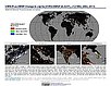
To visualize changes in brightness and extent of global nighttime lights networks over two decades with improved radiometric accuracy and finer spatial resolution. |
|
Global One-Eighth Degree Population Base Year and Projection Grids Based on the SSPs, v1.01 (
|
Global Human Modification of Terrestrial Systems, v1 (2016)Land Use and Land Cover
To provide a cumulative measure of human modification of terrestrial lands based on modeling the physical extents of 13 anthropogenic stressors and their estimated impacts using spatially-explicit global data sets. |
|
Global Development Potential Indices, v1 (2016)Land Use and Land Cover
To provide spatially-explicit data that relatively rank global land suitability referred to as Development Potential Indices (DPIs) for 13 sectors related to renewable energy, fossil fuels, mining and agriculture as an aid to conservation priority setting. |
Latin America and the Caribbean Population Time Series, v1 (1990, 2000)Population DynamicsTo describe changing population distribution and growth in Latin America and the Caribbean using spatially consistent and comparable units at a spatial resolution suitable to regional change analysis. |
|
Natural Resource Protection and Child Health Indicators, 2020 Release (
|
||
Food Insecurity Hotspots Data Set, v1 (
|
Environmental Performance Index, 2020 Release (
|
| 3 of 15 |