Susana Adamo (left) is co-author of an award winning poster on "Aging Populations and Subsequent Tree Cover Expansion, an Investigation in 139 Low- and Middle-Income Countries", presented by Courtney Allen (right) (University of Washington) at the 2024 Meeting of the Population Association of America, held 17-20 April in Columbus, Ohio. The poster was one of five PAA Poster Winners of the session on Neighborhoods, Environment, Spatial Demography, and Data and Methods, which included 98 posters. Co-author Sara Curran (center) (University of Washington) is a former member of SEDAC's User Working Group. Other co-authors of the poster include: Jeff Vincent (Duke University), Kaichao Chang (Duke University, and University of Maryland), and Yi Wang (Duke University and ETH Zurich).
Biodiversity Conservation and Protected Areas
Follow Us: Twitter Follow Us on Facebook YouTube Flickr | Share: Twitter Facebook
1 of 1
Prev
|
Next
|
Most Nations Will Miss 2050 Climate Targets, Finds Latest Environmental Performance Index
June 1, 2022The majority of countries worldwide will fall short of the net-zero goal to reduce greenhouse gas (GHG) emissions by 2050, according to the 2022 Environmental Performance Index (EPI) produced by researchers at the Yale Center for Environmental Law & Policy (YCELP) and CIESIN. The EPI uses emissions data from the past 10 years as a basis for projecting mid-century levels for 180 countries. For the first time India’s EPI score was the lowest among all countries, reflecting its drastically poor air quality and quickly rising GHG emissions. Intensifying air pollution and increasing GHG emissions also placed China towards the bottom of the 2022 scorecard, at 160. Among rich countries, the US was ranked low at 43; although it has reduced its emissions, its starting rate is so high that it is unlikely to make the 2050 target. Countries beset by conflict or other crises such as Myanmar and Haiti or nations that favored economic growth over environmental concerns—for example, Vietnam, Bangladesh, and Pakistan—also received low rankings.
Denmark was again rated the most sustainable nation, with the United Kingdom and Finland close behind owing to success in cutting GHG emissions. Sweden and Switzerland were among high-scoring countries for air and water quality. Offering insights into the drivers of good environmental performance, CIESIN senior research scientist Alex de Sherbinin, one of the lead authors of the 2022 EPI, explained, “Good governance, policy commitment, and targeted environmental investments separate the nations that are moving toward a sustainable future from those that are not. High-scoring countries have well-thought-through programs to protect public health, conserve natural resources, and mitigate greenhouse gas emissions.”
The 2022 EPI used 40 performance indicators to rank 180 countries on their proximity to international targets for addressing air and water pollution, waste management, and biodiversity and habitat protection, as well as the transition to a clean energy future. Even with continuing lags in GHG emissions reduction worldwide, over the past decade significant progress has been made on critical environmental health issues like sanitation, drinking water, and indoor air pollution. YCELP and CIESIN have collaborated in producing the EPI biennially since 2006.
Adapted from a press release by the Yale Center for Environmental Law & Policy.
New Paper on Links between Religion and the Environment
October 2, 2020Alex de Sherbinin, CIESIN associate director for Science Applications, Susana Adamo, research scientist, and Tricia Chai-Onn, senior geographic information specialist, are co-authors of a new study on the link between environmental challenges and religion, published in the Journal of Religion and Demography. Vegard Skirbekk of Columbia University's Mailman School of Public Health is lead author. The paper, “Religious Affiliation and Environmental Challenges in the 21st Century,” builds on a growing body of research carried out at the Columbia Aging Center, where researchers analyzed religious affiliation together with a variety of environment and climate change-related indicators at the country level.
Future Population Scenario Data and Global Development Potential Indices Released
April 16, 2020The NASA Socioeconomic Data and Applications Center (SEDAC) managed by CIESIN has released several new datasets valuable in assessing future global energy development and land use and in characterizing potential long-term future population distribution in the context of climate change.
One dataset, Global One-Eighth Degree Population Base Year and Projection Grids Based on the SSPs, was developed by Bryan Jones of the City University of New York and Brian O’Neill of the University of Denver. The dataset consists of global urban, rural, and total population data for the base year 2000, and population projections at ten-year intervals for 2010-2100 at a resolution of one-eighth degree (7.5 arc-minutes). These are consistent both quantitatively and qualitatively with the Shared Socioeconomic Pathways (SSPs) that were developed in support of the Intergovernmental Panel on Climate Change (IPCC) assessments. A second dataset, Global 1-km Downscaled Population Base Year and Projection Grids Based on the SSPs, provides a downscaled version of the first dataset, at 1-km resolution (about 30 arc-seconds). This dataset was developed by Jing Gao of the National Center for Atmospheric Research (NCAR). Spatial demographic scenario data are key inputs for the analysis of future land use, energy use, and emission patterns together with potential future climate change impacts, vulnerability, and adaptation.
A third dataset, Global Development Potential Indices (DPI), was developed by James Oakleaf of The Nature Conservancy, and colleagues. This dataset ranks global land suitability in the sectors of renewable energy, fossil fuels, mining, and agriculture, to aid in setting priorities for development and conservation efforts. Each sector-based DPI is a 1-km spatially-explicit, global land suitability map that has been validated using locations of current and planned development.
SEDAC is one of NASA′s Distributed Active Archive Centers (DAACs) in the NASA Earth Observing System Data and Information System. SEDAC seeks to improve access to and use of key socioeconomic and interdisciplinary data that are or can be integrated with remote sensing data. SEDAC datasets have been cited in more than 5,000 different scientific publications during the past 20 years.
NASA SEDAC Invites Community Submissions of Human Dimensions Data
July 30, 2019The NASA Socioeconomic Data and Applications Center (SEDAC) operated by CIESIN has begun accepting submissions of scientific data related to human-environment interactions that may be of high utility to the human dimensions research and applications communities. In light of increased recognition of the importance of open access to research data by universities, scientific publishers, funding organizations, and other organizations, SEDAC seeks to increase the accessibility and utilization of important global- or regional-scale spatial data, especially those derived from or complementary to remote sensing data from NASA or other sources. SEDAC will also consider other types of data that meet its acquisition criteria. Priority topics of interest for data acquisition and dissemination include administrative boundaries and other reference layers, population dynamics, human settlements and infrastructure, land use/land cover change, economic development, environmental health, and policy-relevant environmental and sustainable development indicators.
Submission of candidate data sets is a two-step process. In the first step, SEDAC requests basic information on the data (e.g., nature of the data set and its primary purpose) that will help evaluate suitability for SEDAC archiving and dissemination. If the data appear appropriate, a copy of the data will be requested along with additional information for review by the SEDAC User Working Group (UWG). If feasible and appropriate, SEDAC will work with data authors and journal publishers to coordinate data release with publication of a peer-reviewed article. SEDAC will also consider valuable older data sets that may be at risk of loss if not properly archived, as well as national or sub-national data for key countries or regions, on a case-by-case basis.
Recent Departures and Arrivals at CIESIN
June 24, 2019CIESIN bids farewell to Kira Topik, senior research staff assistant, who has moved to the West Coast to pursue other opportunities. Topik began at CIESIN in the summer of 2017 as an intern while pursuing her MA in Columbia University’s Climate and Society program. Previously, she earned a BA in international and intercultural studies, and Spanish, from Pitzer College. Topik supported the communications and coordination needs of the Geo-Referenced Infrastructure and Demographic Data for Development (GRID3) program, helping to establish and operationalize relationships with various partners and stakeholders around the world.
Tiago Nascimento, a doctoral student hosted by CIESIN since June 2018, has completed his visit, returning to the Center for Development and Regional Planning (Cedeplar) at the Universidade Federal de Minas Gerais (UFMG) in Brazil. While at CIESIN, Nascimento conducted research on the spatial mobility of the population in response to the incidence of droughts in Brazil’s Northeast. He has a bachelor’s degree in geography and a master’s degree in demography from the Universidade Federal do Rio Grande do Norte, also in Brazil. CIESIN research scientist Susana Adamo served as his host supervisor.
Prof. Sophie Vanwambeke of the Department of Geography at the UCLouvain in Belgium is finishing her 9-month appointment as a visiting senior research scientist at the end of June. While at Columbia, she worked with Maria Diuk-Wasser of the Department of Ecology, Evolution, and Environmental Biology (E3B) on the ecology and epidemiology of vector-borne diseases and with CIESIN scientists on spatial heterogeneity of population exposure to hazards. She gave an informal talk about her work June 18 at the Lamont campus.
CIESIN has also gained three interns for the summer. Mairead Milán has returned to CIESIN after working as an Earth Institute intern during the spring 2019 semester. She graduated in May with a BA in sustainable development from Columbia College. Milán is working with senior systems analyst/programmer Kytt MacManus, continuing her work on the fifth version of the Gridded Population of the World (GPW) to be developed and released by the NASA Socioeconomic Data and Applications Center (SEDAC). Dorothee Grant is also working with MacManus, helping to integrate population data with night time lights data collected by the Visible Infrared Imaging Radiometer Suite (VIIRS) instrument on the Suomi National Polar-orbiting Partnership (NPP) satellite. Grant is a Columbia College undergraduate majoring in computer science. Sarah Smith, a graduate student in the Climate and Society program, is working with associate director for science applications Alex de Sherbinin on the West Africa Biodiversity and Climate Change (WABiCC) project, which is funded by the US Agency for International Development. She is putting together a manual for adaptation practitioners on incorporating climate information into management strategies. Smith has a BA from Lehigh University in anthropology, with a concentration in physical anthropology.
"The Pack" Takes Computational and Ecological Learning Beyond the Textbook
June 4, 2019A new digital game for players of any age, created by the New York Hall of Science (NYSCI) and Design I/O, uses theories of playful learning to encourage computational thinking and scientific inquiry. CIESIN was a partner in the project, supported by the U.S. National Science Foundation (NSF), that sought to develop innovative ways to teach kids about ecological concepts using approaches drawn from the computer sciences.
The interactive game, The Pack, takes place in a futuristic world called Algos, where food and water are scarce. The challenge of the game is to restore ecosystem balance. The player marshalls different creatures to perform a variety of tasks—digging, moving, holding, grabbing, seeking, and bumping—in order to move water around the environment and find seeds. By arranging and repeating tasks in different order, the player can develop, test, and modify new algorithms to achieve specific objectives.
The Pack is an “open world,” meaning players can explore and choose their objectives more freely than in a linear game with directed goals. As players continue in the game, they encounter increasingly complex opportunities to develop and use their algorithmic thinking skills. For young players, the game seeks to develop a problem-solving mindset and to strengthen social and strategic-thinking skills.
The game leverages increased awareness in the education field that children learn best through play, especially in science. The NYSCI is a pioneer of “design-make-play,” an approach that is central to all of NYSCI's exhibits and activities at its museum location in Queens, New York. Based on the two concepts, awareness of the environment and computational thinking, The Pack is meant for both informal and formal settings in support of Science, Technology, Engineering, Mathematics, and Computing (STEM+C) education.
The Pack was inspired by the award-winning Connected Worlds installation, which came out of a previous NSF-funded collaboration between NYSCI, Design I/O, and CIESIN. This immersive fantastical virtual world lets visitors playfully and tactilely interact with and explore the interdependence of different habitats within a larger ecosystem. The JPB Foundation supported the final production and release of both Connected Worlds and The Pack.
The Pack is free and available for download for Mac OSX, Windows, and iOS devices (iPhone, iPad, and iPod touch). The game is intended for children 4 years old and up. It currently has a rating of 4.8 out of 5 stars in Apple's App Store.

Changing Mangroves, Future Heat Stress, and Data Stewardship Addressed in New Publications
January 4, 2018CIESIN staff and colleagues have capped the end of 2017 and launched 2018 with several new publications on a range of topics. Senior research associate Pinki Mondal is a lead author of a study on long-term changes in mangrove extent in Sierra Leone. The West African country lost 25% of its mangroves between 1990 and 2016, the span of the analysis. Using remote sensing data, the study focuses on four estuaries—Scarcies, Sierra Leone, Yawri Bay, and Sherbro—to provide insight into mangrove management strategies that can support local livelihoods. Sylwia Trzaska, associate research scientist, and Alex de Sherbinin, associate director for Science Applications, are co-authors. The work was funded by the U.S. Agency for International Development (USAID) and conducted in collaboration with Tetra Tech. The paper appears in the journal Sensors, as part of a special issue, “Remote Sensing of Mangrove Ecosystems,” edited by Chandra Giri, an alumnus of CIESIN now with the U.S. Environmental Protection Agency.
Alex de Sherbinin is also co-author of a new global study of heat waves appearing in Environmental Research Letters, among the first research to include humidity as a critical factor in assessing heat stress impacts. The lead authors are Ethan Coffel and Radley Horton of Columbia University and the NASA Goddard Institute for Space Studies (GISS). The study utilizes data available from the NASA Socioeconomic Data and Applications Center (SEDAC) operated by CIESIN—Global Population Projection Grids Based on SSPs, v1 (2010 – 2100)—to quantify the number of people who may be exposed to extreme heat stress in the latter half of this century under different scenarios of development (Shared Socioeconomic Pathways, or SSPs).
Senior digital archivist Robert Downs has three new publications on various data management topics. He authored the chapter, “Enabling the Reuse of Geospatial Information,” in the book, GeoValue: The Socioeconomic Value of Geospatial Information, edited by Jamie B. Kruse, Joep Crompvoets, and Francoise Pearlman and published in November 2017 by CRC Press. He is also a co-author, with Devan Ray Donaldson, Ingrid Dillo, and Sarah Ramdeen, of a peer-reviewed article in the International Journal of Digital Curation on the perceived value of acquiring “data seals of approval,” an international standard for trusted digital repositories. Finally, he has authored the conference paper, “Implementing the Group on Earth Observations Data Management Principles: Lessons from a Scientific Data Center,” in The International Archives of the Photogrammetry, Remote Sensing and Spatial Information Sciences. This was based on his presentation at the 37th International Symposium on Remote Sensing of Environment in Tshwane, South Africa in May 2017 about how the emerging set of data management principles developed by GEO applies to interdisciplinary data management at SEDAC.
- “Landsat-Derived Estimates of Mangrove Extents in the Sierra Leone Coastal Landscape Complex during 1990–2016”
- “Temperature and Humidity Based Projections of a Rapid Rise in Global Heat Stress Exposure During the 21st Century”
- “Humidity May Prove Breaking Point for Some Areas as Temperatures Rise, Says Study” (Press release)
- “Enabling the Use of Geospatial Information”
- “The Perceived Value of Acquiring Data Seals of Approval”
- “Implementing the Group on Earth Observations Data Management Principles: Observations of a Scientific Data Center”
Webinar Features New Superfund Mapping Service
May 8, 2012The new online mapping service, the National Priority List (NPL) Superfund Footprint Mapper, was featured as part of a Webinar sponsored by the National Institute of Environmental Health Sciences (NIEHS) Partnerships for Public Environmental Health (PEPH) on May 7. Participants numbered 158 attendees, more than 30 from federal agencies. Senior research associate Meredith Golden showcased the Mapper with assistance from geographic information specialist Tricia Chai-Onn, who also helped develop the service. Golden highlighted data from several projects of the Socioeconomic Data and Applications Center operated by CIESIN. These include the U.S. Census Grids and the Global Poverty Mapping Project. The NPL Superfund Footprint Mapper can display population and environmental characteristics for areas surrounding more than 1700 NPL Superfund sites. An archived recording of the Webinar will be available soon on the SRP Web site.
2012 EPI Ranks the Environmental Performance of 132 Countries
January 26, 2012Announced at the World Economic Forum held January 25–29 in Davos, Switzerland, the 2012 Environmental Performance Index (EPI) produced by CIESIN and Yale University’s Center for Environmental Law and Policy (YCELP), in collaboration with the World Economic Forum and the Joint Research Center in Ispra, Italy, identifies Switzerland as first in addressing pollution control and natural resource management challenges. Iraq is ranked last. The EPI has been produced every two years since 2006. The 2012 EPI ranks 132 countries, using 22 indicators in ten major policy categories including air and water pollution, climate change, biodiversity, and forest management.
For the first time a complementary index showing country improvement from 2000 to 2010, the Pilot Trend Environmental Performance Index (Trend EPI), was released. Latvia was ranked number one in the Trend EPI, with Russia in last place. The U.S., which is 49th in the EPI, was just 77th in the Trend EPI, implying few recent gains in addressing environmental issues.
Data sets making up the EPI were contributed from the International Energy Agency, remote sensing research groups at Battelle and University of Maryland, the UN Food and Agriculture Organization, and other entities. Lack of data in certain areas—in particular, waste management, toxic exposures, agricultural sustainability and water resources—continue to limit the ability of the EPI to contribute towards the understanding necessary to develop policies for safeguarding the environment.
Search Tool Supports Global Service for Environmental Law Information
April 9, 2010The largest, most comprehensive global information service on environmental law, ECOLEX, combines the environmental law information holdings of the Food and Agriculture Organization (FAO), the International Union for Conservation of Nature (IUCN), and the United Nations Environmental Programme (UNEP) into an accessible and easy-to-use online service. CIESIN is supporting ECOLEX through a search service that enables users to easily search for and obtain Conference of Party (COP) decisions for ten major treaties. The tool was initially developed as part of the Environmental Treaty and Resource Indicators (ENTRI) service of the NASA Socioeconomic Data and Applications Center (SEDAC). The COP decision search tool indexes thousands of decision documents using a Google Search Appliance and has recently been updated with new COP decisions as of April 2, 2010.
Global Data Set Explores Indicators of Coastal Water Quality
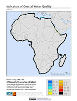
March 31, 2010Over the past few decades coastal waters throughout the world have received an increased influx of nutrients from land-based sources. The resulting change in water quality has many possible implications for coastal and marine ecosystems. In extreme cases eutrophication results, where excess nutrients in the water stimulate excessive plant growth. This can lead to hypoxia—oxygen-depleted “dead zones”—and harmful algal blooms.
Coastal water quality over time may be assessed by measuring chlorophyll concentrations as an indicator of algae biomass. A new global data set, Indicators of Coastal Water Quality, aims to identify near-coastal areas that have improving, declining, and stable chlorophyll concentrations in order to help identify areas that may need management intervention. The data set uses chlorophyll-a concentrations derived from NASA’s sea-viewing wide field-of-view sensor (SeaWiFS) to analyze trends over a ten year period (1998–2007). This data set is a result of a pilot effort, and the methodology will be further refined as part of a NASA Decisions feasibility project.
New Interactive Mapper Previews Human Influence Data
February 5, 2010An interactive mapper has been released as part of the Last of the Wild Web site. This new mapper provides previews of the Last of the Wild, Version Two data sets. Using the mapper, users are now able to visualize the human influence index and the human footprint data sets, overlay national boundaries, or pan and zoom to an area of interest to gain a preliminary understanding about the data sets before downloading them. The mapper was developed using the open source Open Layers client technology with Geoserver backend.
For more advanced visualization and overlay with other related data sets, users may turn to the stand-alone SEDAC Map Client, which is offered via CIESIN’s World Data Center for Human Interactions in the Environment Web site. The Last of The Wild, Version Two data sets depict the extent of human influence on terrestrial ecosystems, using data sets compiled on or around the year 2000.
2010 Index Rates How Close a Country is to Environmental Benchmarks
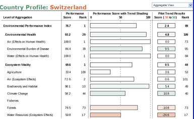
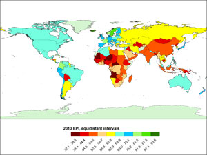
January 28, 2010The 2010 Environmental Performance Index (EPI), which ranks 163 countries on environmental performance, has been released at the World Economic Forum Annual Meeting 2010 in Davos, Switzerland. The Index, produced every two years since 2006 by researchers at CIESIN and Yale University’s Center for Environmental Law and Policy, is based on twenty-five indicators grouped within ten core policy categories—including environmental health, air quality, water resource management, biodiversity and habitat, forestry, fisheries, agriculture, and climate change—in the context of two objectives: environmental health and ecosystem vitality. The EPI’s proximity-to-target approach, in which each country’s performance is measured against clearly defined targets, enables comparisons among countries with very different characteristics.
Although some rankings have changed dramatically—the U.S. dropped from 39th to 61st place since the 2008 index, for example—so too have the methodologies and data. “A better focus is the comprehensive country profiles, which present a measurement across the different environmental indicators,” says CIESIN senior research associate Alex de Sherbinin, a co-author on the report. These profiles, designed by CIESIN research associate Valentina Mara in conjunction with the Yale team, show a country’s scores for the indicators, policy categories, and objectives. Drilling down here, de Sherbinin points out, can help decision makers identify the needed focus of attention for a particular country. Geographic information specialist Malanding Jaiteh, CIESIN deputy director and EPI project leader Marc Levy, and senior research staff assistant Paola Kim were also part of the CIESIN team.
Analysis shows that income is a major factor in high environmental performance, but that policy choices may trump economic capacities. For example, the differences between neighboring countries Chile (ranked 16th) and Argentina (70th), or between Malaysia (55th) and Thailand (68th), have a lot to do with different approaches to environmental policy and governance. The biggest changes this year were seen in the scores for air pollution and effects on ecosystems, and a new indicator, water scarcity, was added. The indicators were drawn from international organizations such as the World Bank, the UN Development Programme (UNDP), and the Food and Agriculture Organization of the United Nations (FAO). Some of the data sets are drawn from government reporting that is not subject to external validation, and incomplete data have resulted in incomplete representation of countries. The report calls for greater investment by the world community in environmental monitoring, and for data sharing and transparency on the part of national governments.
Map Viewer Tutorial Now Available on YouTube Web Site
January 8, 2010TerraViva! SEDAC Viewer is a map viewer and standalone software application that uses a powerful data-viewing engine and tools to enable the visualization and integration of hundreds of socioeconomic and environmental variables and layers, including a range of satellite-based data. A three-part tutorial that explains how to use TerraViva! is now available through the YouTube Web site. The tutorial was produced by senior research associate Alex de Sherbinin and senior media designer Al Pinto, under the auspices of the NASA Socioeconomic Data and Applications Center (SEDAC) operated by CIESIN.
Updated Data, Improved Methodology for 2009 NRMI Release
October 20, 2009The NASA Socioeconomic Data and Applications Center (SEDAC) operated by CIESIN has released the 2009 National Resource Management Index (NRMI). This version of the NRMI has updated data and improved methodology for the eco-region protection indicator, one of the four indicators that make up the NRMI. The improvements included the exclusion of international protected areas, many of which lack effective protection (the ones that do already have a national designation), and improved coastal boundary matching between biomes and national boundaries using the highest resolution coastal data available.
The NRMI is a composite index of four measures. In addition to the eco-region protection indicator, the indicators include: access to improved sanitation, access to improved water, and child mortality. In response to the search for a natural resources management indicator initiated by the the Millennium Challenge Corporation (MCC), the NRMI was first developed in May 2005 by a consortium led by CIESIN and including the Yale Center for Environmental Law and Policy (YCELP), the University of New Hampshire Water Systems Analysis Group, the Wildlife Conservation Society, and the Columbia University Tropical Agriculture Program. The MCC uses the NRMI as as one of its performance indicators to help determine country eligibility for its foreign aid programs.
Human Biomes Defined, Data Available, on New Web Site
October 1, 2009Anthropogenic biomes, also known as “anthromes” or “human biomes,” describe the terrestrial biosphere in its contemporary, human-altered form using global ecosystem units defined by patterns of sustained direct human interaction. In a paper presented in the journal, Frontiers in Ecology and the Environment, Ellis and Ramankutty (2008) delineate 21 anthropogenic biomes based on population density, land use, biota, climate, terrain and geology. The anthropogenic biomes are further grouped into six major categories: dense settlements, villages, croplands, rangeland, forested, and wildlands. A new Web site, “Anthropogenic Biomes (version one),” provides access to the spatial data sets described in the paper. Available in raster GeoTiff and GRID formats, the data may be downloaded as one global grid or a grid for each of the six populated continents. The methodology involves a multi-stage procedure where “anthropogenic” cells are first separated from “wild” cells based on presence of population, crops, or pastures. A detailed description of the methods utilized to produce the data, as well as research results, may be downloaded from the Web site.
New NRMI Conservation Data Added to SEDAC Map Client
March 26, 2009In support of CIESIN’s Natural Resource Management Index (NRMI) contribution to the Millennium Challenge Corporation (MCC), CIESIN’s SEDAC program has added to its Internet map client the protected areas “mask” and the World Wildlife Fund terrestrial biome data upon which the 2008 NRMI ecoregion protection indicator was calculated.
This tool will help countries assess their protected area coverage by biome in order to better understand their ecoregion protection indicator score. Further information on the methodology used to calculate the ecoregion protection indicator is available from the MCC/NRMI Web site.
CIESIN Data Featured in Paris Exhibition on Environmental Change
March 18, 2009A recent art exhibition in Paris made prominent use of data developed by CIESIN. The exhibition, Terre Natale: Ailleurs Commence Ici (Native Land: Stop Eject), by Raymond Depardon and Paul Virilio, was presented at Fondation/Cartier/ pour l’art contemporain from November 21, 2008 to March 15, 2009. As part of the exhibition, professor Laura Kurgan, director of the Spatial Information Design Lab at Columbia University’s Graduate School of Architecture, Planning and Preservation, co-authored a collaborative design of video presentation that immersed viewers with images from a nearly-360 degree projection displayed throughout a circular room. The 30-minute video, which utilizes data from CIESIN’s Gridded Population of the World (GPW) data collection and Global Rural-Urban Mapping Project (GRUMP) available from the Socioeconomic Data and Applications Center (SEDAC), includes a moving globe that dynamically illustrates the economic, political, and environmental causes of global migration. “We translated the gridded population data from pixels into numbers and graphs and then animated it, overlaying many other kinds of data about migration such as displacement from floods, voluntary economic migration as seen through remittances, and refugee flows archived by UNHCR,” explained Kurgan. “The piece communicates to scientific, policy, and general audiences—and from children to NGOs—as a device for expressing complex ideas in simple ways.” The exhibition catalog, published by the museum, is available in both English and French.
Progress Toward Environmental Performance Index for China Reviewed at Beijing Meeting
February 8, 2009
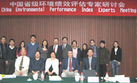
Attendees of experts meeting in Beijing to review progress toward an environmental performance index for China. Front row, left to right: Xiaoshi Xing, Wang Jinnan, Christine Kim, Alex de Sherbinin, Cao Dong. Back row: Staff of CAEP, YCELP, and City University of Hong Kong, with CIESIN’s Marc Levy (sixth from left). |
CIESIN deputy director Marc Levy, senior research associate Alex de Sherbinin, and information scientist Xiaoshi Xing participated in an experts meeting in Beijing February 5, the purpose of which was to review data and indicators for the China Environmental Performance Index (EPI). The meeting was co-organized with the Chinese Academy for Environmental Planning (CAEP) and the Yale Center for Environmental Law and Policy (YCELP). CIESIN and YCELP were responsible for leading development of the 2008 EPI, a global environmental performance assessment which ranked 149 countries on 25 indicators tracked across six established policy categories. The China EPI is expected to be released in September 2009.
1 of 1
Prev
|
Next
|