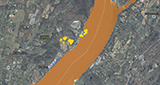
An easy-to-use mapping tool visualizes building footprint data for nearly all New York State’s infrastructure, except New York City. Highly interactive, it requires only Internet access, ensuring that communities with fewer resources can create comprehensive flood scenarios for planning, response, and policymaking.