Gridded Population of the World (GPW), v4
Follow Us: Twitter Follow Us on Facebook YouTube Flickr | Share: Twitter FacebookWhat's New in GPWv4
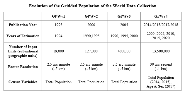
The Gridded Population of the World (GPW) data collection was first developed in 1994 to provide a spatially-disaggregated population layer that is compatible with data sets from social, economic, and Earth science disciplines. In the 20 years since it was first created, GPW has been substantially expanded and enhanced with each subsequent version, as seen in the table below.

The current version of GPW, version 4 (GPWv4), provides a major update to the underlying population and spatial data and includes methodological improvements over past versions of the data collection.
More current data
GPWv4 has been updated using the most recently available census data. The data primarily come from the 2010 round of censuses, which spanned from 2005 to 2014. By comparison, GPWv3 used data from the 2000 round of censuses, which spanned from 1995 to 2004. GPWv4 provides population estimates for five target years: 2000, 2005, 2010, 2015, and 2020.
Finer raster resolution
Unlike previous versions of GPW that were gridded at a 2.5 arc-minute (~5 km) raster resolution, GPWv4 is now gridded at a much smaller pixel size: 30 arc-second or approximately 1 km at the equator. This raster resolution is now standard among global gridded population data sets. By using a finer pixel resolution, GPWv4 can take advantage of the high resolution spatial data provided by many countries, resulting in a more accurate population surface.
More input administrative units
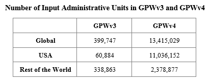
Since the release of GPWv1, the number of input administrative units greatly increased with each subsequent version. GPWv4 is no exception. Its 13.5 million input units represent a 34-fold increase over GPWv3, 106-fold over GPWv2, and 710-fold over GPWv1. The table below compares the number of input administrative units between GPWv3 and GPWv4.

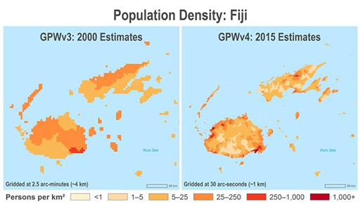
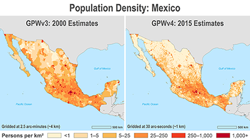
The images below show examples of how the finer grid resolution and greater number of input census units in GPWv4 can combine to provide more detailed and precise population grids.

In GPWv3, Fiji was gridded using 15 provinces from 2001 population data. In GPWv4, Fiji was gridded using 1,602 enumeration areas from the 2007 Census of Population and Housing.

In GPWv3, Mexico was gridded using 2,414 municipios from the 2000 Census. In GPWv4, population was gridded using 76,314 basic geostatistical units from the 2010 Census.
To see the previous version of GPW, visit the GPWv3 data collection.