Gridded Population of the World (GPW), v4
What's New in Revision 10
In July 2016, SEDAC released the Gridded Population of the World, version 4 (GPWv4) data collection which included seven raster data sets available at 30 arc-second resolution in GeoTIFF format, and one vector data set of administrative unit center points. For this release, the eight 4.0 data sets originally released with version 4 were updated, and a ninth data set, on basic demographic characteristics (age and sex), was added. The nine data sets, collectively referred to as the Revision 10 (or v4.10) data sets, incorporated boundary or population updates for 64 countries, additional attributes in the centroids and national identifier data sets, an updated water mask which includes more recent glacier data and local water data sources for high latitude countries, and additional format and resolution options. A log of changes to the data sets by version is available on the Documentation web page and is included with each downloaded data set.
Basic Demographic Characteristics
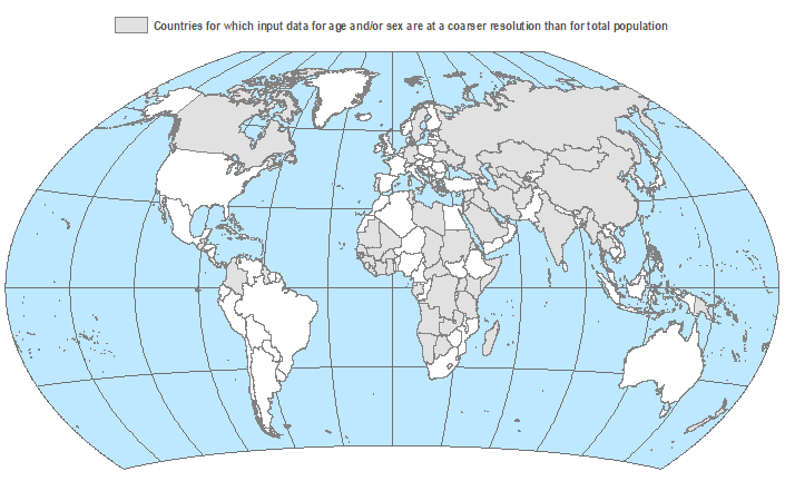
The Basic Demographic Characteristics, v4.10 (2010) data set is new with this release of GPWv4. It provides estimates of human population by age and sex as counts (number of persons per pixel) and densities (number of persons per square kilometer), consistent with national censuses and population registers, for the year 2010. To estimate the male and female populations by age in 2010, the proportions of males and females in each 5-year age group from ages 0-4 to ages 85+ for the given census year were calculated. These proportions were then applied to the 2010 estimates of the total population to obtain 2010 estimates of male and female populations by age. In some cases, the spatial resolution of the age and sex proportions was coarser than the resolution of the total population estimates to which they were applied (See map below and Appendix F in the data collection documentation). The data are produced as rasters of 5-year age groups and broad age groups, as totals and by sex. A raster of women of childbearing age is also available.
Additional Formats and Resolutions
With this release, all of the 4.10 raster data sets are now available in ASCII format as well as GeoTIFF. Five data sets are also available in netCDF format. The native 30 arc-second resolution data were aggregated to four lower resolutions (2.5 arc-minute, 15 arc-minute, 20 arc-minute, and 1 degree) to enable faster global processing and support of research communities that conduct analyses at these resolutions. The data are available in all five resolutions in ASCII and GeoTIFF formats. NetCDF files are available in all resolutions except 30 arc-second.
Data sets available in netCDF format:
- Population Count, v4.10 (2000, 2005, 2010, 2015, 2020)
- Population Density, v4.10 (2000, 2005, 2010, 2015, 2020)
- UN WPP-Adjusted Population Count, v4.10 (2000, 2005, 2010, 2015, 2020)
- UN WPP-Adjusted Population Density, v4.10 (2000, 2005, 2010, 2015, 2020)
- Basic Demographic Characteristics, v4.10 (2010)
Country-Level Changes
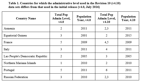
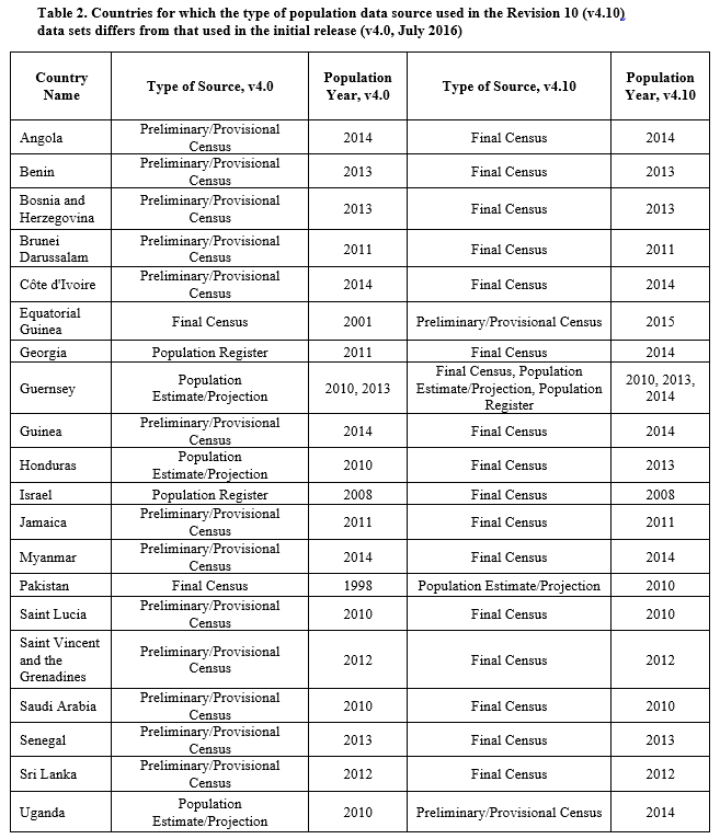
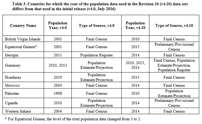
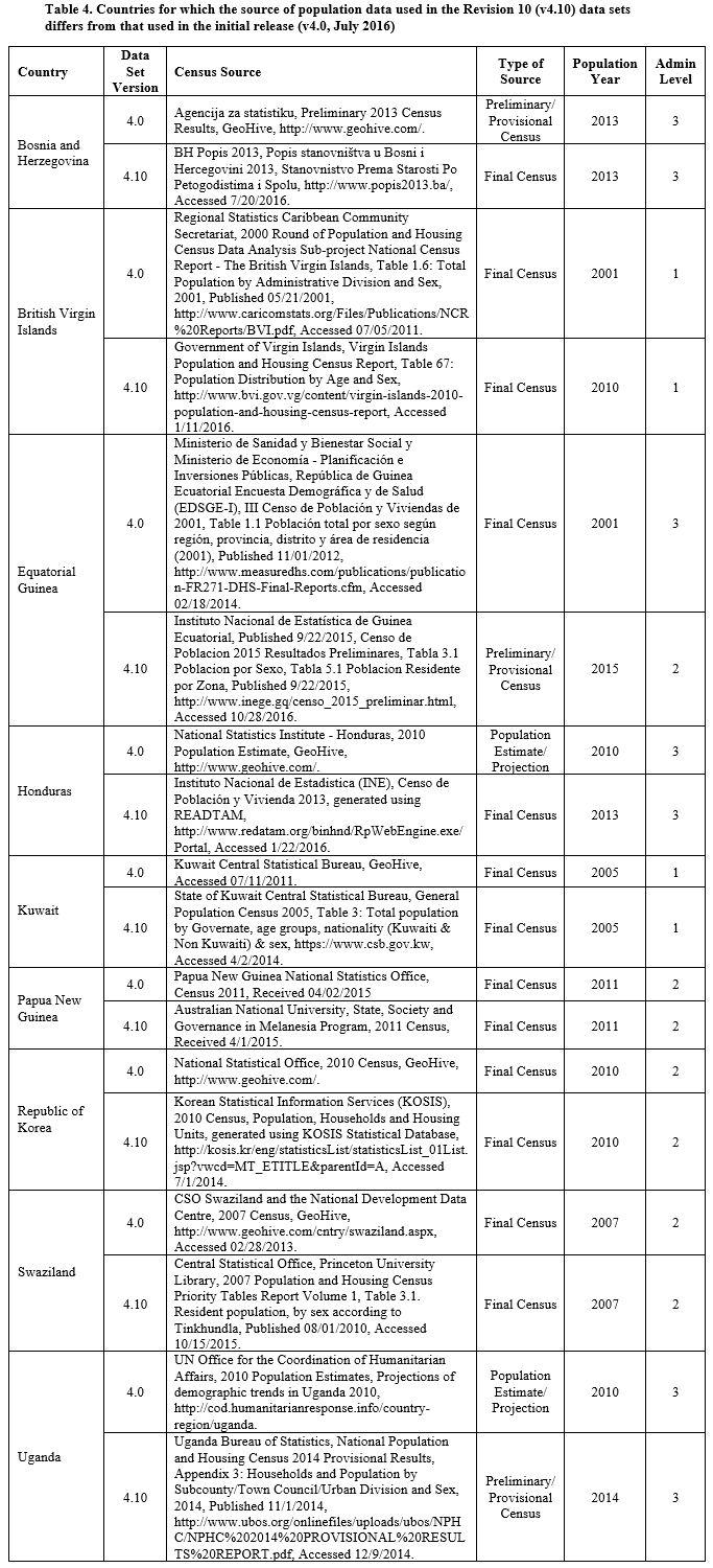
Details about the country-level differences in input data between the release of the 4.0 data sets and the 4.10 data sets are available in Tables 1-4 below. These tables highlight countries for which the administrative level (Table 1), type of population data source (Table 2), year of the population data source (Table 3), or source of the population data (Table 4) used in the Revision 10 data sets differs from that used in the 4.0 data sets. A log of changes to the data sets by version is also available and further identifies additional countries that have been updated.
To see the previous version of GPW, visit the GPWv3 data collection.