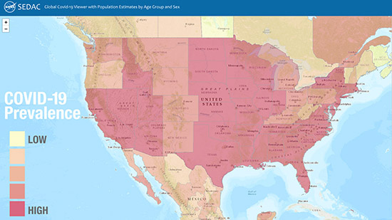
NASA Website Socioeconomic Data and Applications Center (sedac)
A Data Center in NASA's Earth Observing System Data and Information System (EOSDIS) — Hosted by CIESIN at Columbia University
Data
  • Data Sets
  • Maps
  • Web Pages
  • home
  • Data
    • · Data Sets
    • · Data Collections
    • · Featured Data Uses
    • · Data Citations
    • · Citations Database
    • · Data Submission
  • Maps
    • · Map Gallery
    • · Map Viewer
    • · Map Services
    • · Mapping Tools
  • Themes
    • · Agriculture
    • · Climate
    • · Conservation
    • · Governance
    • · Hazards
    • · Health
    • · Infrastructure
    • · Land Use
    • · Marine and Coastal
    • · Population
    • · Poverty
    • · Remote Sensing
    • · Sustainability
    • · Urban
    • · Water
  • Resources
    • · Guides
    • · Multimedia
    • · Networks
    • · News
    • · Publications
    • · Related Sites
    • · Remote Sensing
    • · Tools
  • Social Media
    • · Twitter
    • · FaceBook
    • · YouTube
    • · Flickr
    • · Blog Posts
    • · Communities
  • About
    • · About SEDAC
    • · User Working Group
    • · Privacy
    • · User Registration
  • Help
 

Population Distribution and Change

Follow Us: Twitter Follow Us on Facebook YouTube Flickr   |   Share: Twitter Facebook
  • Theme Home
  • Data Sets
  • Map Gallery
  • Map Services
  • Featured Data Uses
  • Resources
    • Guides
    • Multimedia
    • Networks
    • News
    • Publications
    • Related Sites
    • Tools
2 of 4
Prev | Next
 

CIESIN Staff Participate in Virtual Meetings on Key Data Issues

September 24, 2020

During August and September, CIESIN scientists contributed to numerous online meetings and Webinars focused on diverse issues related to citizen science data, data quality and stewardship, geospatial data development and applications, and climate migration modeling and data.

Senior digital archivist Robert Downs gave the presentation, “Improving Data Stewardship Based on the TRUST Principles for Digital Repositories,” at the #WeMissiPRES virtual meeting on 23 September. The annual International Conference on Digital Preservation (iPRES) was cancelled due to the COVID-19 pandemic, and was replaced by a virtual event consisting of three half-day sessions September 22–24. Downs′ presentation focused on the ongoing implementation of the TRUST Principles (transparency, responsibility, user focus, sustainability, and technology) at the NASA Socioeconomic Data and Applications Center (SEDAC) operated by CIESIN. Downs also presented, “NASA Socioeconomic Data and Applications Center (SEDAC): Current Status, Road Map and Challenges,″ during a virtual meeting of the World Data System (WDS) Harvestable Metadata Services (HMetS) Working Group on September 9.

Alex de Sherbinin, associate director for Science Applications, gave the talk, “Data for the Sustainable Development Goals in Africa: The role of citizen-generated data,” at a Technical Validation Workshop on September 16 for the project, Standardizing City-Level Data-Gathering for Achieving Sustainable Development Goal 11 in Africa (SCiLeD). On 14 September, he also served as a panelist during the 2020 Global Shifts Colloquium, organized by the Perry World House at the University Pennsylvania, where he presented work on climate migration modeling and data sources. 

August 26–27 and September 4, CIESIN participated as an observer organization in the virtual Tenth Session of the United Nations Group of Experts on Global Geospatial Information Management (UN-GGIM). CIESIN′s delegation was led by director Robert Chen. The UN-GGIM promotes international collaboration on geospatial  data and information and reports on all matters relating to geography, geospatial information, and related topics to the UN Economic and Social Council (ECOSOC). CIESIN has been a non-governmental organization with special consultative status recognized by ECOSOC since 1995.

At the 2020 Earth Science Information Partners (ESIP) Summer Meeting Highlights Webinar on August 13, Robert Downs gave a lightning talk summarizing the ESIP Information Quality Cluster session, “Citizen Science and Data Quality.” The Webinar provided an overview of plenary and breakout sessions from the Summer Meeting, and is available for viewing on YouTube.

New Publications Released on Climate Risk, Citizen Science Data, Data Quality, and Boundary Data

September 19, 2020

Alex de Sherbinin, associate director for Science Applications, is guest editor of a special Issue of the journal Sustainability on climate risk and vulnerability mapping, with co-editor Stefan Kienberger of the University of Salzburg. He is also a co-author of one of the papers in the special issue, on using flood disaster data to validate components of social vulnerability to floods. The paper’s lead author is Earth Institute Fellow Beth Tellman.

The article, “Still in Need of Norms: The State of the Data in Citizen Science,″ has been published in the journal Citizen Science: Theory and Practice. Anne Bowser of the Wilson Center is lead author, and de Sherbinin is a co-author. The article is a major output of the CODATA-World Data System (WDS) Task Group on Citizen Science and the Validation, Curation, and Management of Crowdsourced Data, which de Sherbinin co-chaired in 2016-2018.

Senior digital archivist Robert Downs is a co-author of the report, “Laying the Groundwork for Developing International Community Guidelines to Effectively Share and Reuse Digital Data Quality Information—Case Statement, Workshop Summary Report, and Path Forward,” published in Open Science Foundation (OSF) Preprints. Ge Peng of the Earth Science Information Partners (ESIP) Information Quality Cluster is lead author. The report, which stems from a pre-workshop held in July 2020 prior to the ESIP Summer Meeting, describes the approach that will be taken to develop community guidelines for preparing and sharing data quality information.

The Geo-Referenced Infrastructure and Demographic Data for Development (GRID3) program managed by CIESIN has released the white paper, “Harmonizing Subnational Boundaries,” on GRID3 efforts to support the harmonization, production, and use of digitized legal/administrative units, operational units, and statistical areas. This work addresses three primary areas: improving and harmonizing operational units; fostering improved collaboration on boundary harmonization among disparate government bodies; and using boundaries harmonization to support census efforts. The paper focuses on case studies in Nigeria, the Democratic Republic of the Congo, and Zambia.

See:
  • Special Issue: “Climate Risk and Vulnerability Mapping″
  • Paper: “Using Disaster Outcomes to Validate Components of Social Vulnerability to Floods: Flood Deaths and Property Damage across the USA″
  • Paper: “Still in Need of Norms: The State of the Data in Citizen Science″
  • Report: “Laying the Groundwork for Developing International Community Guidelines to Share and Reuse Digital Data Quality Information—Case Statement, Workshop Summary Report, and Path Forward
  • White Paper: “Harmonizing Subnational Boundaries”

New Earth Institute Fellow to Study Extreme Heat Events and Their Impacts

September 4, 2020

Cascade Tuholske has joined CIESIN for a two-year appointment as an Earth Institute postdoctoral research scientist. Tuholske is a geographer specializing in the integration of global-scale human and environment geospatial data to examine the relationship between urbanization and climate change. At CIESIN, he has begun working with director Robert Chen and associate director for Science Applications Alex de Sherbinin to construct a globally extensive, longitudinal, and fine-scale synthesis of extreme heat events, urban population growth, and the urban heat island effect. His goal is to inform adaptation strategies that reduce the harmful and inequitable impacts of urban exposure to extreme heat. He will also contribute to another NASA-funded project on the use of gridded population and settlement datasets to assess progress towards the United Nations Sustainable Development Goals (SDGs). Tuholske received his PhD in geography from the University of California, Santa Barbara, where he focused on the nexus of climate change, urbanization, and food security in Africa under the guidance of Prof. Kelly Caylor.

CIESIN Alumna Appointed Director of Institute for Demographic Research at City University of New York

August 4, 2020

Former CIESIN scientist Deborah Balk has assumed the directorship of the Institute for Demographic Research (IDR) at the City University of New York (CUNY). She had served as IDR′s associate director since 2006. Balk is also professor of public affairs at the Austin W. Marxe School of Public and International Affairs at Baruch College. She serves on several noteworthy committees, including the National Research Council (NRC) Committee on Population, the U.S. Census Bureau’s Scientific Advisory Committee, and the New York City Panel on Climate Change, for which she is a co-chair. She was an Andrew Carnegie Fellow 2016–2018. Her research focus is urbanization in the developing world, using a spatial framework to explore the demographic implications of climate-change issues. Balk is currently working with Kytt MacManus, senior systems analyst/GIS developer at CIESIN, and with Gordon McGranahan of the Institute of Development Studies in the United Kingdom, on updates to the low-elevation coastal zone estimates developed in a 2007 study. She was lead project scientist for the NASA Socioeconomic Data and Applications Center (SEDAC) operated by CIESIN from 1998 to 2006, spearheading the development of many widely-used population-related data products and services. She later served as a member of SEDAC′s User Working Group (UWG) 2015–2018.

Interns Join CIESIN Projects and Programs for the Summer

July 12, 2020

Several new interns have joined CIESIN this summer, working remotely due to closure of CIESIN offices along with the rest of Columbia University during the COVID-19 pandemic.

Alexandra Hays is working with senior systems analyst/GIS developer Kytt MacManus on the third version of the Urban-Rural Population and Land Area Estimates, which is part of the Low Elevation Coastal Zone (LECZ) data collection developed by the NASA Socioeconomic Data and Applications Center (SEDAC). Hays is a senior at Columbia University majoring in economics, with a concentration in sustainable development. Interns Serena Killion and Caitlyn Linehan are also working with MacManus, on analysis of nighttime lights data and development of map services for SEDAC. Killion is a senior at Columbia, majoring in computer science; Linehan is completing her MS in geographic information systems (GIS) at City University of New York-Lehman College.

Four interns are working with Greg Yetman, associate director for geospatial applications, on a project supported by the New York State Energy Research and Development Authority (NYSERDA) to assess potential flood impacts on building infrastructure. Elizabeth Jackson and Elan Ganeles are juniors at Columbia; Jackson is majoring in sustainable development, and Ganeles is majoring in urban studies and earth science. Chris Mangnani is a senior at Columbia majoring in sustainable development. Siobhan Milán is a junior from the University of Virginia, majoring in economics with a minor in statistics.

Interns under CIESIN’s Geo-Referenced Infrastructure and Demographic Data for Development (GRID3) program include Mariem Ayadi, Zane Peycke, and Nancy Yun, who are completing their MS degrees in data science at Columbia′s Data Science Institute. Ayadi is working with data and program analyst Jolynn Schmidt and senior research associate Paola Kim-Blanco, creating a model that checks for errors in building footprints data. Peycke and Yun are both working with Schmidt; Peycke is is cleaning and compiling points of interest data for the Democratic Republic of Congo, and Yun is cleaning and compiling health facility data for countries in sub-Saharan Africa.

New Data and Indicators Released on Resource Protection, Child Health, Urban Change, and India′s Population

July 6, 2020

The NASA Socioeconomic Data and Applications Center (SEDAC) operated by CIESIN has released the 2019 annual update to the Natural Resource Protection Indicators (NRPI) and Child Health Indicators (CHI) together with two new spatial data sets developed by former SEDAC project scientists Christopher Small of the Lamont-Doherty Earth Observatory (LDEO) and Deborah Balk of the City University of New York (CUNY).

Natural Resource Protection and Child Health Indicators, 2019 Release supports the annual country selection process conducted by the Millennium Challenge Corporation (MCC), which bases its selection criteria on a basket of governance, social, economic, and environmental indicators. For 2019, the NRPI covers 234 countries and is calculated based on the weighted average percentage of biomes under protected status. The CHI is a composite index for 195 countries derived from the average of three proximity-to-target scores.

Spatial Data from the 2011 India Census, v1 contains gridded estimates of India′s population at 1-kilometer resolution, with two spatial renderings of urban areas: one based on official tabulations of population and settlement type and the other based on the Global Human Settlement Layer (GHSL). The data set was developed by a team led by former CIESIN research scientist Deborah Balk, who is now associate director of CUNY’s Institute for Demographic Research. It is part of SEDAC′s India Data Collection.

VIIRS Plus DMSP Change in Lights, v1 provides changes in brightness and extent of global nighttime lights networks over two decades (1992, 2002, 2013). The nightime lights imagery was sourced from the U.S. Air Force Defense Meteorological Satellite Program (DMSP) Operational Linescan System (OLS) and the Suomi National Polar-orbiting Partnership (NPP) Visible Infrared Imaging Radiometer Suite (VIIRS) Day-Night Band. It was developed by Christopher Small and several CIESIN geospatial experts. The data set was used to assess urban growth and development in Asian megadeltas, described in a paper published in 2018 in Global and Planetary Change. The data set is part of SEDAC's collection, Satellite-Derived Environmental Indicators.

All of these data are available for free download from SEDAC (registration with Earthdata required). The India and nighttime lights data may be visualized through the SEDAC Map Viewer or open web services.

SEDAC Updates Global COVID-19 Viewer and Population Data Comparison Tool

July 3, 2020

The NASA Socioeconomic Data and Applications Center (SEDAC) operated by CIESIN has updated two of its online mapping tools with new data and functionality. The latest version of the tool, the SEDAC Global COVID-19 Viewer: Population Estimates by Age Group and Sex, provides new visualizations of COVID-19 data in relationship to population characteristics and other potentially relevant factors. Users may now view rates of COVID-19 cases and mortality per 100k people; age pyramids and population numbers for user-defined areas; trend data on cases at the country, state (province), or county level where available; and more.

The POPGRID Viewer, a tool designed to facilitate visualization and intercomparison of the many different global-scale gridded population data sets now available, has been updated with new and more complete versions of the six population data sets included. Data for two different time periods are now included for three data sets. Users may view any combination of data in a unique four-panel viewer, and then compare population estimates for all six data sets for a specific area of interest. The POPGRID Viewer was developed by SEDAC in support of the POPGRID Data Collaborative, an initiative launched by CIESIN in 2017 to bring together both the developers and users of global georeferenced population data. 

Cyberseminar Focuses on Population, Climate Change, and Food Security

May 26, 2020

The Population-Environment Research Network (PERN) held an online cyberseminar May 18–25 on analysis of the population-climate change-food security nexus. The cyberseminar was moderated by Raya Muttarak of the University of East Anglia and included statements by seven expert panelists from a range of disciplines. A webinar launching the cyberseminar May 18 was led by Alex de Sherbinin, associate director for Science Applications. He and CIESIN research scientist Susana Adamo are co-coordinators of PERN, which is a panel of the International Union for the Scientific Study of Population (IUSSP) and a sustained partner of Future Earth. PERN is supported by the NASA Socioeonomic Data and Applications Center (SEDAC) operated by CIESIN. A YouTube video of the webinar is available online, and background materials from the cyberseminar are posted on the PERN website.

See:
  • Webinar: Population, Climate Change, and Food Security
  • Cyberseminar background materials

New Report Provides Guidance on Using Gridded Population Data

May 13, 2020

A new report from the Thematic Research Network on Data and Statistics (TReNDS) of the United Nations Sustainable Development Solutions Network (SDSN) provides guidance on the use of gridded population datasets from the POPGRID Data Collaborative. The report, Leaving No One Off the Map: A Guide for Gridded Population Data for Sustainable Development, reviews population data products from POPGRID members, including CIESIN, Esri, Oak Ridge National Laboratory, and the WorldPop Project, among others. The report was written by Hayden Dahmm and Maryam Rabiee, with input from Jessica Espey, all of SDSN TReNDS. CIESIN research scientist Susana Adamo, associate director for Science Applications Alex de Sherbinin, and CIESIN director Robert Chen also contributed to the report, along with other POPGRID participants and CIESIN staff members. POPGRID was launched in 2017 through an Earth Institute seed grant led by Chen and is supported in part by the Bill and Melinda Gates Foundation and the NASA Socioeconomic Data and Applications Center (SEDAC) operated by CIESIN.

On May 18 a live virtual debate hosted and moderated by SciDev.net and SDSN TReNDS featured panelist Alex de Sherbinin; Jessica Espey, TReNDS director; Andrea Gaughan of the University of Louisville and contributor to the WorldPop Project; and Idris Jega, assistant director with the Strategic Space Applications Department at Nigeria‘s National Space Research and Development Agency. Jega is also a member of the Nigeria secretariat for the GRID3 program managed by CIESIN. The panel discussed the importance of gridded population data and their utility in helping to achieve the Sustainable Development Goals (SDGs) established in 2015 by the United Nations.

See:
  • Leaving No One Off the Map: A Guide for Gridded Population Data for Sustainable Development
  • Short Video

Future Population Scenario Data and Global Development Potential Indices Released

April 16, 2020

The NASA Socioeconomic Data and Applications Center (SEDAC) managed by CIESIN has released several new datasets valuable in assessing future global energy development and land use and in characterizing potential long-term future population distribution in the context of climate change.

One dataset, Global One-Eighth Degree Population Base Year and Projection Grids Based on the SSPs, was developed by Bryan Jones of the City University of New York and Brian O’Neill of the University of Denver. The dataset consists of global urban, rural, and total population data for the base year 2000, and population projections at ten-year intervals for 2010-2100 at a resolution of one-eighth degree (7.5 arc-minutes). These are consistent both quantitatively and qualitatively with the Shared Socioeconomic Pathways (SSPs) that were developed in support of the Intergovernmental Panel on Climate Change (IPCC) assessments. A second dataset, Global 1-km Downscaled Population Base Year and Projection Grids Based on the SSPs, provides a downscaled version of the first dataset, at 1-km resolution (about 30 arc-seconds). This dataset was developed by Jing Gao of the National Center for Atmospheric Research (NCAR). Spatial demographic scenario data are key inputs for the analysis of future land use, energy use, and emission patterns together with potential future climate change impacts, vulnerability, and adaptation.

A third dataset, Global Development Potential Indices (DPI), was developed by James Oakleaf of The Nature Conservancy, and colleagues. This dataset ranks global land suitability in the sectors of renewable energy, fossil fuels, mining, and agriculture, to aid in setting priorities for development and conservation efforts. Each sector-based DPI is a 1-km spatially-explicit, global land suitability map that has been validated using locations of current and planned development.

SEDAC is one of NASA′s Distributed Active Archive Centers (DAACs) in the NASA Earth Observing System Data and Information System. SEDAC seeks to improve access to and use of key socioeconomic and interdisciplinary data that are or can be integrated with remote sensing data. SEDAC datasets have been cited in more than 5,000 different scientific publications during the past 20 years.

See:
  • Global One-Eighth Degree Population Base Year and Projection Grids Based on the SSPs, v1.01 (2000 – 2100)
  • Global 1-km Downscaled Population Base Year and Projection Grids Based on the SSPs, v1.01 (2000 – 2100)
  • Global Development Potential Indices (DPI)

New Map Viewer Shows Population Characteristics in Relation to Reported COVID-19 Cases

April 10, 2020
screenshot of New York City showing age distribution of defined area

A new mapping tool shows the density of population in relationship to reported coronavirus disease (COVID-19) cases at national and sub-national levels, and permits users to obtain custom estimates of the number of people by age and sex living in an area of interest, including areas not currently reporting large numbers of cases.

Developed by the NASA Socioeconomic Data and Applications Center (SEDAC), the SEDAC Global COVID-19 Viewer: Population Estimates by Age Group and Sex lets users quickly access relevant population information without having to download and analyze large amounts of spatial population data. The Viewer’s unique capability is that it allows users to obtain population estimates for specific age and sex categories for any area, such as a metropolitan region that cuts across multiple jurisdictions or countries. The Viewer displays age and sex structure charts and pyramids in response to a user-drawn circle or polygon. Data on COVID-19 cases from the Johns Hopkins University are updated multiple times per day.

The SEDAC Global COVID-19 Viewer is meant for researchers, educators, and policymakers who are interested in visualizing key population characteristics such as high concentrations of elderly individuals in urban or rural areas that are, or may become, affected by the COVID-19 pandemic. The Viewer may be especially helpful for regional analyses or for countries with limited access to spatial population data. The underlying population data are from SEDAC’s Gridded Population of the World (GPW) Basic Demographic Characteristics, v4.11, for the year 2010, with estimates to 2020. The COVID-19 data are from Johns Hopkins University & Medicine Coronavirus Resource Center. SEDAC is one of the NASA Distributed Active Archive Centers (DAACs) and is operated by the Center for International Earth Science Information Network (CIESIN) of the Earth Institute at Columbia University.

See:
  • The SEDAC Global COVID-19 Viewer

POPGRID Data Collaborative Updates Web Site, Announces Webinar

January 24, 2020
screenshot of POPGRID Home page

The POPGRID Data Collaborative, an initiative launched by CIESIN in 2017 to improve the quality, access, and use of global-scale spatial data on human population, settlements, and infrastructure, has recently updated its Web site and announced an international Webinar to be held February 4 in collaboration with Geospatial World.

The POPGRID Web site helps users learn about the many different gridded population data sets now available, providing detailed background information and documentation, and direct links to the data and data sources. In addition, the POPGRID Viewer lets users easily compare different data products for their specific regions of interest. The updated site now includes links to recent publications and recorded Webinars about gridded population data, together with updated information from the data providers. POPGRID is collaboratively managed by CIESIN, the Thematic Research Network on Data and Statistics (TReNDS) of the United Nations Sustainable Development Solutions Network, and the Global Partnership for Sustainable Development Data, and is supported by the Bill & Melinda Gates Foundation and NASA. More than 20 different groups from both the public and private sectors are active in the POPGRID Data Collaborative. The POPGRID Viewer was developed by the NASA Socioeconomic Data and Applications Center (SEDAC) operated by CIESIN.

On February 4, CIESIN director Robert Chen and Maryam Rabiee of TReNDS presented the Webinar, “Leaving No One Off the Map: Gridded Population Data for Decision Making,″ in coordination with Geospatial World. It attracted 150 participants from around the world. The Webinar focused on how gridded population data can help decision makers and other applied users improve efforts to achieve the Sustainable Development Goals (SDGs) adopted by the international community in 2015, and in particular to help reach those who might otherwise be left behind. Recent advances in mapping make it possible to better determine the location and characteristics of human settlements and households, allowing for more effective and efficient assistance, e.g., for vaccination campaigns, development assistance, and humanitarian relief. However, the proliferation of different data sets utilizing different methods and sources may confuse users about which data sets are the most appropriate to use in different situations. The Webinar discussed ongoing efforts by the POPGRID Data Collaborative to address this issue, and ways in which the geospatial community can both benefit from, and participate in, POPGRID activities. A recording is available here.

See:
  • POPGRID Data Collaborative Web Site

New Spatial Data on U.S. Urban Extent and Global Pesticide Use Released

January 3, 2020

The NASA Socioeconomic Data and Applications Center (SEDAC) operated by CIESIN has released two new data sets, one focused on a new approach for assessing urban extent in the continental U.S. and a second that estimates the potential exposure of major food crops around the world to selected chemicals used in pesticides.

Urban Extents from VIIRS and MODIS for the Continental U.S. Using Machine Learning Methods is a highly accurate urban settlement layer at a spatial resolution of 500 meters that is based in part on nighttime lights data from NASA’s Black Marble project. Machine learning methods were used to provide a more consistent, quantitative measure of urban extent, drawing on observations collected at high temporal frequency by the Visible Infrared Imaging Radiometer Suite (VIIRS) and Moderate Resolution Imaging Spectroradiometer (MODIS) remote sensing instruments. The data set was developed by former CIESIN scientist Xue Liu, now at Harvard University′s Center for Geographic Analysis, together with SEDAC deputy manager Alex de Sherbinin and former staff member Yanni Zhan. The derivation of the data set is described in a recent open access article by Liu et al. in the journal Remote Sensing.

The Global Pesticide Grids (PEST-CHEMGRIDS) data set was developed by Federico Maggi of the University of Sydney and colleagues, to assess human and ecosystem exposure to potential and recognized toxic chemicals, for the purposes of environmental modelling and assessment of agricultural chemical contamination and risk. PEST-CHEMGRIDS includes comprehensive data on the 20 most-used pesticide active ingredients, on six dominant crops and four aggregated crop classes, at 5 arc-minute resolution (about 10 kilometers at the equator), estimated for the year 2015 and projected to 2020 and 2025. The data set includes 200 data quality maps for each active ingredient on each crop. The data set is described in detail in a recent open access paper by Maggi et al. published in the journal Scientific Data. 

These data are distributed as part of SEDAC′s mission to archive and disseminate key socioeconomic and related environmental data sets that either utilize or complement satellite-based remote sensing data, in support of scientific research, applications, and education. Data selection is overseen by SEDAC′s User Working Group (UWG). Data set authors are invited to submit their data for possible SEDAC archiving and open dissemination; for the submission criteria and form, please see the SEDAC Data Submission page.

See:
  • Urban Extents from VIIRS and MODIS for the Continental U.S. Using Machine Learning Methods
  • Global Pesticide Grids (PEST-CHEMGRIDS), v1 (2015, 2020, 2025)

Earth Science Researchers Gather for Fall Meeting of the American Geophysical Union

December 17, 2019

The largest international Earth and space science conference in the world, the annual American Geophysical Union (AGU) fall meeting, brought more than 25,000 scientists and other experts to San Francisco December 9–13. CIESIN staff members organized or co-organized seven sessions; presented more than twelve invited, oral, e-lightning, and poster papers; and served as co-authors on at least nine other papers. CIESIN director Robert Chen convened three sessions on exposure and vulnerability assessment for hazard, coastal, climate, and health risks and served as co-chair of one of them. Associate director for Science Applications Alex de Sherbinin also co-chaired the poster session in this series. Senior digital archivist Robert Downs co-organized a session on improving use of the FAIR principles (Findable, Accessible, Interoperable, and Reusable), as well as several sessions on the use of earth and space science data.

Also attending the conference were associate director for Geospatial Applications Greg Yetman, GIS developer Kytt MacManus, and Columbia College student Dorothee Cleophee Grant, a former summer intern. Yetman gave an oral presentation on population data models for settlement extents and a NASA Hyperwall talk, “Are You at Risk? Linking Hazard and Exposure Data for Research and Applications.” MacManus gave an oral presentation on new sources for the updated version of low-elevation coastal zone data, expected to be released in early 2020. He also presented a poster paper on a nighttime lights dataset recently released by the NASA Socioeconomic Data and Applications Center (SEDAC), to which Grant had contributed.

While at the conference, de Sherbinin gave invited talks and served as a panelist in three different sessions on open data digital repositories for developing countries, climate vulnerability mapping, and managed retreat due to climate change. Chen gave presentations on the FAIR principles and open data and on the use of Earth Observations to operationalize the fundamental geospatial data themes established by the United Nations. Downs gave an e-lightning talk on citing open data and presented a case study on data sharing and data management guidance developed by the Group on Earth Observations (GEO). Both Downs and Chen also served as judges on student papers.

See:
  • American Geophysical Union 2019 Fall Meeting
  • APPENDIX: Fall AGU 2019 Sessions, Papers, and Presentations with CIESIN Staff Participation ((175 PDF)

Webinars Highlight Gridded Population Data and International Data Sharing and Management Principles

December 11, 2019

CIESIN staff members presented two online webinars during the week of December 2, for which recordings are now available.

The webinar, “Gridded Population and Settlement Data for Human Dimensions Research—An Introduction to the POPGRID Data Collaborative,″ was held December 3 as part of NASA′s EarthData Webinar Series. The POPGRID Data Collaborative is a coalition of data providers, users, and other stakeholders that aims to improve the quality, accessibility, and utility of global-scale spatial data on human settlements, infrastructure, and population. The Webinar provides an introduction to the growing diversity of gridded data, including many that utilize new sources of remote sensing data, as well as an overview of gridding approaches. CIESIN associate director for Science Applications Alex de Sherbinin and GIS developer Kytt MacManus also demonstrated the SEDAC POPGRID Viewer, which enables users to easily compare different data products for their specific regions of interest. The Viewer was developed by the NASA Socioeconomic Data and Applications Center (SEDAC) operated by CIESIN. The POPGRID Data Collaborative is supported by the Bill & Melinda Gates Foundation, and is co-led by CIESIN, the Thematic Research Network on Data and Statistics (TReNDS) of the United Nations Sustainable Development Solutions Network, and the Global Partnership for Sustainable Development Data.

On December 6, CIESIN director Robert Chen presented in a second Webinar, “Data Management Principles,″ part of the monthly NextGEOSS Webinar Series and co-organized by the Open Geospatial Consortium. He gave an overview of the Global Earth Observing System of Systems (GEOSS) Data Sharing and Data Management Principles (DSDMPs), which have been developed by the Group on Earth Observations (GEO). NextGEOSS is a centralized European Earth Observation data hub and platform, supported by the European Commission as a contribution to GEOSS. The Webinar also included a presentation by Sylvie Jourdain of METEO France on application of the GEOSS Data Management Principles to the rescue of historical climate data, and a discussion of the relationship between the GEOSS DSDMPs and the Findable, Accessible, Interoperable, Reusable (FAIR) Principles. CIESIN senior digital archivist Robert Downs co-authored the presentations. Both Chen and Downs are members of the GEO Data Sharing and Data Management Working Group, which was recently formed at the GEO-XVI Plenary and Ministerial Summit in Canberra, Australia.

See:
  • NASA EarthData Webinar, “Gridded Population and Settlement Data for Human Dimensions Research—An Introduction to the POPGRID Data Collaborative″
  • NextGEOSS webinar, "Data Management Principles"

Migration and Poverty Mapping Discussed at Recent University Meetings

October 25, 2019
Photo of panel discussion, “Ending Poverty through Multilateral Cooperation: Global Actions and Local Impacts,”

CIESIN research scientist Susana Adamo, right, participated in a panel discussion, “Ending Poverty through Multilateral Cooperation: Global Actions and Local Impacts,” October 15 at Columbia's School of International and Public Affairs in New York City. Daniel Naujoks is to her left; Luis Felipe López-Calva is to the far left.

CIESIN research scientist Susana Adamo attended the conference, “Demographic Responses to Changes in the Natural Environment,” organized by the University of Wisconsin-Madison's Center for Demography & Ecology/Applied Population Laboratory October 24–25 in Madison, Wisconsin. She presented a poster highlighting the report, Groundswell: Preparing for Internal Migration, on the influence of longer-term climate impacts on internal migration. The report was produced by World Bank staff and a team of researchers at CIESIN, the City University of New York Institute for Demographic Research, and the Potsdam Institute for Climate Impact Research.

Earlier in the month Adamo participated in the panel discussion, “Ending Poverty through Multilateral Cooperation: Global Actions and Local Impacts,” at Columbia University’s School of International and Public Affairs in New York City October 15. Adamo described SEDAC’s poverty mapping collection, highlighting the recently updated Global Subnational Infant Mortality Rates v2 data set. She also discussed the importance of geospatial data for meeting and monitoring the Sustainable Development Goals (SDGs).

See:
  • Conference: “Demographic Responses to Changes in the Natural Environment”

Integration of Statistics and Geography Addressed at European Forum

October 22, 2019

CIESIN geographic information specialist Jane Mills and senior geographic information specialist Linda Pistolesi were among the presenters at the 2019 European Forum for Geography and Statistics (EFGS), organized in Manchester, England, October 9–11. This year′s forum focused on how the integration of statistics and place can enhance understanding of diverse population and world issues. In the session, “Future Geospatial Thinking,” Mills outlined plans for the fifth version of Gridded Population (GPW) of the World now under development, and discussed progress made by the POPGRID Data Collaborative, an initiative to promote data access and use of diverse georeferenced data sets on population, human settlements, and infrastructure. For the session, “Leaving No One Behind,” Pistolesi presented two strategies implemented by the Geo-Referenced Infrastructure and Demographic Data for Development (GRID3) program to improve subnational boundaries in low- and middle-income countries. The 2019 EFGS was organized by the Office for National Statistics and Ordnance Survey Great Britain with support from the Statistical Office of the European Union and the EFGS.

See:
  • European Forum for Geography and Statistics 2019
  • Gridded Population of the World (GPW) version 5: Building and using a global collection of subnational data. European Forum of Geography and Statistics (6.75 MB PDF)
  • Mapping subnational boundaries: The GRID3 approach

Cyberseminar Focuses on Use of Gridded Population Data in Population-Environment Research

October 21, 2019

A “cyberseminar” presenting various gridded population and settlement data products and their suitability for different application areas in population-environment studies was offered October 14–18 by the Population-Environment Research Network (PERN) in collaboration with the POPGRID Data Collaborative. Seven expert panelists and more than 700 researchers and practitioners from around the world participated. Andrea Gaughan of the University of Louisville and the WorldPop project facilitated the discussion. An initial webinar was held October 14 to introduce the topic and is available on YouTube. The initial paper, discussion papers, and cyberseminar posts are available through the PERN web site.

PERN cyberseminars provide a forum for scientists from the social and natural sciences to debate and discuss cutting edge population-environment research topics. CIESIN research scientist Susana Adamo and associate director of Science Applications Alex de Sherbinin are PERN′s co-coordinators. PERN is a scientific panel of the International Union for the Scientific Study of Population (IUSSP) and a sustained partner of Future Earth, an international initiative to advance global sustainability science. The POPGRID Data Collaborative is supported by the Bill & Melinda Gates Foundation.

See:
  • PERN Webinar—Gridded Population & Settlement Products in Geospatial Pop-Environment Research
  • PERN Cyberseminar page

HazPop Mobile App Now Available for Both iOS and Android Platforms

September 27, 2019
screenshot from Hazards and Population Mapper (HazPop) mobile application

The Hazards and Population Mapper (HazPop) mobile app, a tool designed to put hazard-related data and information at your fingertips, is now available on both smartphones and tablets running iOS and Android. HazPop simplifies access to a range of distributed data services providing near-real-time data, including active fires and air pollution data (Aerosol Optical Depth) from NASA, earthquake alerts from the U.S. Geological Survey (USGS), and volcanic activity from the Smithsonian Institution's Global Volcanism Program. These data may be viewed in combination with data on population distribution and infrastructure, such as major dams and reservoirs and nuclear power plants, provided by the NASA Socioeconomic Data and Applications Center (SEDAC) operated by CIESIN.

Users interested in knowing how many people might be affected by a current or potential hazard may draw a circle around their own location or any other point of interest to obtain population estimates during the period 2000–2020.

HazPop is meant for those who need a quick assessment of the population potentially at risk from a major hazard event or developing emergency, such as disaster risk managers, humanitarian response organizations, public health professionals, and journalists. It is not intended to support in-depth risk assessment or estimation of actual disaster losses.

The app may be downloaded for free from the Apple App Store or from Google Play. It is compatible with iPhone, iPad, and iPod touch running iOS 9.0 or later, and with smartphones and tablets with Android 5.0 or later.

­

See:
  • HazPop for iOS (Apple App Store)
  • HazPop for Android (Google Play)

CIESIN Scientists Contribute to Diverse Population-Environment Publications

September 12, 2019

Several publications authored or co-authored by CIESIN staff have been published recently. Associate director for Science Applications Alex de Sherbinin is lead author of the paper, “Climate Vulnerability Mapping: A Systematic Review and Future Prospects,” appearing in the peer-reviewed journal, WIREs Climate Change. The article reports on a study to systematically assess 84 climate vulnerability mapping studies, with the goal of encouraging further methodological refinement and identifying outstanding examples that could help to guide future work in this area. The study benefited from two workshops held in 2017 supported by National Socio‐Environmental Synthesis Center (SESYNC) and funded by the U.S. National Science Foundation.

The article, “Allocating People to Pixels: A Review of Large-Scale Gridded Population Data Products and Their Fitness for Use,” has been published in the journal Earth Systems Science Data. The lead author is Stefan Leyk of the University of Colorado. CIESIN contributors are de Sherbinin, research scientist Susana Adamo, senior systems analyst Kytt MacManus, senior geographic information specialist Linda Pistolesi, and deputy director Marc Levy. Former CIESIN research scientist Deborah Balk, who is now associate director of the Institute for Demographic Research at the City University of New York (CUNY), is also a co-author. The paper is an outcome of the POPGRID Data Collaborative, an international effort to coordinate and improve the utility of global-scale gridded population data.

Former CIESIN visiting scholar Douglas Sathler is lead author of “Assessing the Regional Context of Migration in the Brazilian Amazon through Spatial Regression Modeling” in the journal Applied Geography. Co-authors include Adamo, de Sherbinin, and senior research associate Paola Kim-Blanco. The article examines spatial patterns of both in-migration and outimigration in the Brazilian Amazon during the period 2000–2010. Sathler is a researcher with the Center for Geosciences of the Interdisciplinary College in Humanities at the Federal University of Vales do Jequitinhonha e Mucuri (UFVJM) in Diamantina, Brazil.

Greg Yetman, associate director for Geospatial Applications, is a co-author on the paper, “Evaluating Nighttime Lights and Population Distribution as Proxies for Mapping Anthropogenic CO2 Emission in Vietnam, Cambodia, and Laos.” Andrea Gaughan of the University of Louisville is lead author of the paper, which was published in Environmental Research Communications. The paper stems from work organized by the WorldPop project.

Senior digital archivist Robert Downs is lead author of the Technical Note, “Reuse Readiness Assessment of Data Quality Software Products (ESDS-RFC-039),” co-authored with Hampapuram Ramapriyan of Science Systems and Applications, Inc. and Yang Wei of the Oak Ridge National Laboratory (ORNL) Distributed Active Archive Center (DAAC). The Data Quality Working Group of the Earth Science Data and Information System (ESDIS) Standards Office (ESO) recommends this assessment for use in NASA Earth Science Data Systems.

See:
  • “Climate Vulnerability Mapping: A Systematic Review and Future Prospects”
  • “Allocating People to Pixels: A Review of Large-Scale Gridded Population Data Products and Their Fitness for Use"
  • “Assessing the Regional Context of Migration in the Brazilian Amazon through Spatial Regression Modeling”
  • “Evaluating Nighttime Lights and Population Distribution as Proxies for Mapping Anthropogenic CO2 Emission in Vietnam, Cambodia, and Laos”
  • “Reuse Readiness Assessment of Data Quality Software Products (ESDS-RFC-039)”
2 of 4
Prev | Next
 

Home | Data | Data Uses | Data Citations | Maps | Map Services

News | Tools | Guides | Publications | Blog Posts

About | Help | Privacy | User Registration

Copyright © 1997–2023. The Trustees of Columbia University in the City of New York.

WDS ICSU