NASA Website Socioeconomic Data and Applications Center (sedac)
A Data Center in NASA's Earth Observing System Data and Information System (EOSDIS) — Hosted by CIESIN at Columbia University
Data
  • Data Sets
  • Maps
  • Web Pages
  • home
  • Data
    • · Data Sets
    • · Data Collections
    • · Featured Data Uses
    • · Data Citations
    • · Citations Database
    • · Data Submission
  • Maps
    • · Map Gallery
    • · Map Viewer
    • · Map Services
    • · Mapping Tools
  • Themes
    • · Agriculture
    • · Climate
    • · Conservation
    • · Governance
    • · Hazards
    • · Health
    • · Infrastructure
    • · Land Use
    • · Marine and Coastal
    • · Population
    • · Poverty
    • · Remote Sensing
    • · Sustainability
    • · Urban
    • · Water
  • Resources
    • · Guides
    • · Multimedia
    • · Networks
    • · News
    • · Publications
    • · Related Sites
    • · Remote Sensing
    • · Tools
  • Social Media
    • · Twitter
    • · FaceBook
    • · YouTube
    • · Flickr
    • · Blog Posts
    • · Communities
  • About
    • · About SEDAC
    • · User Working Group
    • · Privacy
    • · User Registration
  • Help
 

Urbanization and Human Settlements

Follow Us: Twitter Follow Us on Facebook YouTube Flickr   |   Share: Twitter Facebook
  • Theme Home
  • Data Sets
  • Map Gallery
  • Map Services
  • Featured Data Uses
  • Resources
    • Guides
    • Multimedia
    • Networks
    • Publications
    • Related Sites
2 of 3
Prev | Next
 

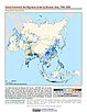
Population Density Grid, v1 (1990, 1995, 2000)

Global Rural-Urban Mapping Project (GRUMP), v1

  • Overview
  • Download
  • (212) Maps
  • (4) WMS

To provide a time series of raster population density data for data integration.

National Administrative Boundaries, v1 (2000)

Global Rural-Urban Mapping Project (GRUMP), v1

  • Overview
  • Download

To permit cartographic display of countries and territories that exactly match the GRUMPv1 population surfaces

Settlement Points, v1 (1990, 1995, 2000)

Global Rural-Urban Mapping Project (GRUMP), v1

  • Overview
  • Download
  • (213) Maps
  • (1) WMS

To provide populated place (point) data with consistent population estimates.

Coastlines, v1 (2000)

Global Rural-Urban Mapping Project (GRUMP), v1

  • Overview
  • Download

To permit cartographic display of coastlines that exactly match the GRUMPv1 population surfaces.

National Identifier Grid, v1 (1995, 2000, 2010)

Global Rural-Urban Mapping Project (GRUMP), v1

  • Overview
  • Download

To permit the summation of population values by country/territory and, in combination with other data layers, the summation of population values by irregular areas represented in the other data layers and country/territory.

Urban Extent Polygons, v1.02 (1995)

Global Rural-Urban Mapping Project (GRUMP), v1

  • Overview
  • Download
  • Documents

To provide a polygon representation of urban areas with city or agglomeration name and time series population estimates.

Global Human Built-up And Settlement Extent (HBASE) Dataset From Landsat, v1 (2010)

Global High Resolution Urban Data from Landsat

  • Overview
  • Download
  • Documents
  • (2) Maps

To provide high spatial resolution estimates of global urban extent derived from global 30m Landsat satellite data for the target year 2010 and a companion dataset to the Global Man-made Impervious Surface (GMIS) dataset.

Global Man-made Impervious Surface (GMIS) Dataset From Landsat, v1 (2010)

Global High Resolution Urban Data from Landsat

  • Overview
  • Download
  • Documents
  • (2) Maps

To provide high spatial resolution estimates of global man-made imperviousness for the target year 2010, derived from global 30m Landsat satellite data and a companion dataset to the Global Human Built-up And Settlement Extent (HBASE) dataset.

Daily and Annual PM2.5, O3, and NO2 Concentrations at ZIP Codes for the Contiguous U.S., v1 (2000 – 2016)

Air Quality Data for Health-Related Applications

  • Overview
  • Download
  • Documents

To provide daily and annual Fine Particulate Matter (PM2.5), Ozone (O3), and Nitrogen Dioxide (NO2) concentrations data at ZIP Codes for the contiguous U.S. for research in environmental epidemiology, environmental justice, and health equity by linking with ZIP Code-level demographic and medical data sets, and for other related research.

Development Threat Index, v1 (2015)

Land Use and Land Cover (LULC)

  • Overview
  • Download
  • Documents
  • (10) Maps
  • (10) WMS

To provide a future development threat map based on combining these resources: agricultural expansion, urban expansion, conventional oil and gas, unconventional oil and gas, coal, mining, biofuels, solar, and wind.

Global Estimated Net Migration Grids By Decade, v1 (1970 – 2000)

Population Dynamics

  • Overview
  • Download
  • Documents
  • (18) Maps
  • (3) WMS

To provide estimates of net-migration (in-migration minus out-migration) per one-kilometer grid cell on a decadal basis for the 1970s, 1980s, and 1990s.

MA Ecosystems, v1 (2000)

Millennium Ecosystem Assessment (MA)

  • Overview
  • Download
  • Documents

To preserve access to the original ecosystems data used by the Millennium Ecosystem Assessment (MA) and other related research.

Subset of OpenStreetMap Roads, v1 (2014)

West Africa Coastal Vulnerability Mapping

  • Overview
  • Download
  • Documents

To provide roads linking rural production to urban markets in the coastal zone of West Africa that represent an important exposed infrastructure asset.

Subset of JRC Map of Accessibility, v1 (1987 – 2008)

West Africa Coastal Vulnerability Mapping

  • Overview
  • Download
  • Documents

To provide market accessibility in the coastal zone of West Africa.

Subset of DMSP-OLS Nighttime Lights for Economic Activity, v1 (2010)

West Africa Coastal Vulnerability Mapping

  • Overview
  • Download
  • Documents

To provide a measure of economic activity in the coastal zone of West Africa based on nighttime lights.

Economic Systems Index, v1 (2000, 2010)

West Africa Coastal Vulnerability Mapping

  • Overview
  • Download
  • Documents

To assess relative levels of economic activity in the coastal zone of West Africa.

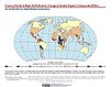
Country Trends in Major Air Pollutants, v1 (2003 – 2018)

Air Quality Data for Health-Related Applications

  • Overview
  • Download
  • Documents
  • (6) Maps

To provide a framework of public-health-focused air quality indicators that quantifies country trends in exposure to major air pollutants.

Annual PM2.5 Concentrations for Countries and Urban Areas, v1 (1998 – 2016)

Satellite-Derived Environmental Indicators

  • Overview
  • Download
  • Documents

To provide an annual global surface of concentrations (micrograms per cubic meter) of mineral dust and sea-salt filtered fine particulate matter of 2.5 micrometers or smaller (PM2.5) in countries and urban areas for large-scale health and environmental research

Global (GL) Annual PM2.5 Grids from MODIS, MISR and SeaWiFS Aerosol Optical Depth (AOD), v4.03 (1998 – 2019)

Satellite-Derived Environmental Indicators

  • Overview
  • Download
  • Documents
  • (5) Maps

To provide an annual global surface of concentrations (micrograms per cubic meter) of all composition ground-level fine particulate matter of 2.5 micrometers or smaller (PM2.5) for large-scale health and environmental research.

Global 3-Year Running Mean Ground-Level NO2 Grids from GOME, SCIAMACHY and GOME-2, v1 (1996 – 2012)

Satellite-Derived Environmental Indicators

  • Overview
  • Download
  • Documents
  • (2) Maps
  • (2) WMS

To provide a continuous surface of NO2 concentrations for health and environmental research.

2 of 3
Prev | Next
 

Home | Data | Data Uses | Data Citations | Maps | Map Services

News | Tools | Guides | Publications | Blog Posts

About | Help | Privacy | User Registration

Copyright © 1997–2023. The Trustees of Columbia University in the City of New York.

WDS ICSU