Urbanization and Human Settlements
|
3 of 3
Prev
|
Next
|
SDG Indicator 11.2.1: Urban Access to Public Transport, 2023 Release (
|
SDG Indicator 11.7.1: Urban Public Space, Availability and Access, 2023 Release (
|
|
Annual PM2.5 Concentrations for Countries and Urban Areas, v1 (
|
Global (GL) Annual PM2.5 Grids from MODIS, MISR and SeaWiFS Aerosol Optical Depth (AOD), v4.03 (
|
|
MA Rapid Land Cover Change, v1 (
|
||
SSPs Literature Database, v1 (
|
Global Roads Open Access Data Set (gROADS), v1 (
|
|
Global Monthly and Seasonal Urban and Land Backscatter Time Series, v1 (
|
Sub-global Scenarios that Extend the Global SSP Narratives: Literature Database, v1 (
|
|
ATSDR Hazardous Waste Site Polygon Data, v2 (2010)Superfund Site FootprintsTo provide the ATSDR polygon data set of hazardous waste sites in the United States, Puerto Rico, and other territories which can be used to identify nearby populations and assess their potential risk. |
ATSDR Hazardous Waste Site Polygon Data with CIESIN Modifications, v2 (2010)Superfund Site FootprintsTo provide an easily accessible, corrected data set of polygons for hazardous waste sites in the United States which can be used to identify nearby populations and assess their potential risk. |
|
U.S. EPA National Priorities List Sites with CIESIN Modifications, v2 (2014)Superfund Site Footprints
To provide an easily accessible, corrected EPA data set of the geo-referenced locations displayed as points for all the National Priorities List (NPL) Superfund sites in the United States, Puerto Rico, and other territories. |
U.S. Population Grids (Summary File 1): New Orleans Metropolitan Statistical Area, alpha (2000)Natural Disasters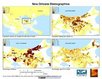
To provide gridded demographic data, including characteristics of age, race, ethnicity, and housing, for metropolitan statistical areas at a finer resolution than is available in the 30 arc-second grids used for the United States as a whole. |
|
U.S. Population Grids (Summary File 3): New Orleans Metropolitan Statistical Area, alpha (2000)Natural DisastersTo provide gridded demographic data, including characteristics of income, poverty, education, and housing age, for New Orleans. |
U.S. Population Grids (Summary File 1): Houston Metropolitan Statistical Area, alpha (2000)Natural Disasters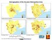
To provide gridded demographic data, including characteristics of age, race, ethnicity, and housing, for metropolitan statistical areas at a finer resolution than is available in the 30 arc-second grids used for the United States as a whole. |
|


|
3 of 3
Prev
|
Next
|