Data Sets (58)
|
1 of 3
Prev
|
Next
|
Daily 8-Hour Maximum and Annual O3 Concentrations for the Contiguous United States, 1-km Grids, v1.10 (
|
Daily and Annual PM2.5 Concentrations for the Contiguous United States, 1-km Grids, v1.10 (
|
|
Daily and Annual NO2 Concentrations for the Contiguous United States, 1-km Grids, v1.10 (
|
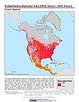
Annual Mean PM2.5 Components (EC, NH4, NO3, OC, SO4) 50m Urban and 1km Non-Urban Area Grids for Contiguous U.S., v1 (
|
|
Annual Mean PM2.5 Components Trace Elements (TEs) 50m Urban and 1km Non-Urban Area Grids for Contiguous U.S., v1 (
|
Annual Global High-Resolution Extreme Heat Estimates (GEHE), v1 (
|
|
Yale Center for Earth Observation (YCEO) Surface Urban Heat Islands, v4 (
|
Sub-global Scenarios that Extend the Global SSP Narratives: Literature Database, v1 (
|
|
U.S. Social Vulnerability Index Grids, v1.01 (2000, 2010, 2014, 2016, 2018, 2020)U.S. Census Grids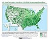
To provide a 1 km grid of the CDC Social Vulnerability Index (SVI) aligned with CIESIN's Gridded Population of the World, Version 4, Revision 11 (GPWv4.11) with a mask for water and no population. |
Global (GL) Annual PM2.5 Grids from MODIS, MISR and SeaWiFS Aerosol Optical Depth (AOD), v4.03 (
|
|
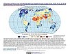
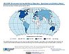
INFORM Global Risk Index 2019 Mid Year, v0.3.7, (2019)Intergovernmental Panel on Climate ChangeTo assess country-level vulnerability and coping capacity related to climate change based on the data set used in Chapter 8 of the Sixth Assessment Report (AR6) by the Intergovernmental Panel on Climate Change (IPCC) Working Group II (WGII). |
Daily and Annual NO2 Concentrations for the Contiguous United States, 1-km Grids, v1 (
|
|
Global Gridded Relative Deprivation Index (GRDI), v1 (
|
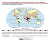
Country Trends in Major Air Pollutants, v1 (
|
|
Environmental Performance Index, 2022 Release (
|
Daily and Annual PM2.5, O3, and NO2 Concentrations at ZIP Codes for the Contiguous U.S., v1 (
|
|
Annual PM2.5 Concentrations for Countries and Urban Areas, v1 (
|
Global High Resolution Daily Extreme Urban Heat Exposure (UHE-Daily), v1 (
|
|
Global Subnational Infant Mortality Rates, v2.01 (2015)Poverty Mapping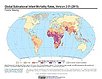
To provide a global subnational map of infant mortality rate estimates for the year 2015, to be used by a wide user community in interdisciplinary studies of health, poverty, and the environment. |
SSPs Literature Database, v1 (
|
|
1 of 3
Prev
|
Next
|