Data Sets (39)
|
1 of 2
Prev
|
Next
|
Groundswell Africa Spatial Population and Migration Projections at One-Eighth Degree According to SSPs and RCPs, v1 (
|
Sub-global Scenarios that Extend the Global SSP Narratives: Literature Database, v1 (
|
|
Water Security (WSIM-GLDAS) Monthly Grids, v1 (
|
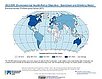
Environmental Performance Index, 2022 Release (
|
|
Groundswell Spatial Population and Migration Projections at One-Eighth Degree According to SSPs and RCPs, v1 (
|
SSPs Literature Database, v1 (
|
|
Environmental Performance Index, 2020 Release (
|
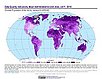
Trends in Global Freshwater Availability from the Gravity Recovery and Climate Experiment (GRACE), v1 (
|
|
Environmental Performance Index, 2018 Release (
|
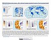
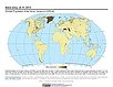
Fifth Assessment Report (AR5) Observed Climate Change Impacts, v2.01 (
|
|
Environmental Performance Index, 2016 Release (
|
Environmental Performance Index, 2014 Release (
|
|
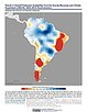
Sea Level Rise Impacts on Ramsar Wetlands of International Importance, v1 (
|
Environmental Performance Index and Pilot Trend Environmental Performance Index, 2012 Release (
|
|
Dams, v1.01 (2011)Global Reservoir and Dam (GRanD), v1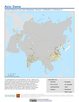
To provide a geographically explicit and reliable database of dams for the scientific community. |
Reservoirs, v1.01 (2011)Global Reservoir and Dam (GRanD), v1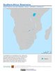
To provide a geographically explicit and reliable database of reservoirs for the scientific community. |
|
Croplands, v1 (2000)Global Agricultural Lands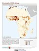
To provide data on the extent of croplands for research on human-environment interactions. |
Environmental Performance Index, 2010 Release (
|

|
1 of 2
Prev
|
Next
|