Data Sets (296)
| 11 of 15 |
Global Cyclone Proportional Economic Loss Risk Deciles, v1 (2000)Natural Disaster Hotspots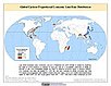
To provide a spatial surface of the proportional economic impacts of global cyclone hazard. |
Global Earthquake Mortality Risks and Distribution, v1 (2000)Natural Disaster Hotspots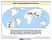
To provide a means of assessing global earthquake mortality risks and distribution. |
|
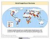
Global Flood Proportional Economic Loss Risk Deciles, v1 (2000)Natural Disaster Hotspots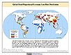
To provide a spatial surface of the proportional economic impacts of global flood hazard. |
Global Flood Mortality Risks and Distribution, v1 (2000)Natural Disaster Hotspots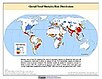
To provide a means of assessing global flood mortality risks and distribution. |
|
Global Earthquake Total Economic Loss Risk Deciles, v1 (2000)Natural Disaster Hotspots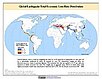
To provide a spatial surface of the total economic impacts of global earthquake hazard. |
Global Drought Hazard Frequency and Distribution, v1 (
|
|
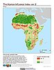
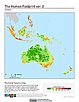
Global Human Influence Index (Geographic), v2 (
|
Global Human Footprint (IGHP), v2 (
|
|
Global Human Influence Index (IGHP), v2 (
|
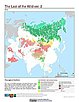
Last of the Wild (Geographic), v2 (
|
|
Global Human Footprint (Geographic), v2 (
|
Last of the Wild (IGHP), v2 (
|
|
MA Climate and Land Cover, v1 (
|
MA Ecosystems, v1 (2000)Millennium Ecosystem Assessment (MA)To preserve access to the original ecosystems data used by the Millennium Ecosystem Assessment (MA) and other related research. |
|
MA Population, v1 (
|
MA Rapid Land Cover Change, v1 (
|
|
Unsatisfied Basic Needs, v1 (
|
Small Area Estimates of Poverty and Inequality, v1 (
|
|
Global Subnational Prevalence of Child Malnutrition, v1 (
|
Poverty and Food Security Case Studies, v1 (
|

| 11 of 15 |