Data Sets (296)
| 13 of 15 |
Global 15 x 15 Minute Grids of the Downscaled Population Based on the SRES B2 Scenario, v1 (1990, 2025)Socioeconomic Downscaled Projections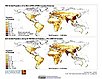
To provide a gridded data on country-level population and downscaled projections based on the SRES B2 marker scenario. |
Global 15 x 15 Minute Grids of the Downscaled GDP Based on the SRES B2 Scenario, v1 (1990, 2025)Socioeconomic Downscaled Projections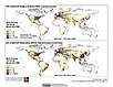
To provide gridded GDP data on country-level downscaled projections based on the SRES B2 marker scenario. |
|
Global Patterns of HANPP, v1 (1995)Human Appropriation of Net Primary Productivity (HANPP)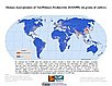
To assist in understanding human impacts on the environment, and especially impacts on biodiversity and ecosystem services. |
Global Patterns in Net Primary Productivity, v1 (1995)Human Appropriation of Net Primary Productivity (HANPP)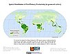
To be utilized in conjunction with a data set of human appropriation of net primary productivity (HANPP) in order to understand global energy flows and localized impacts on the environment. |
|
HANPP as a Percentage of Net Primary Productivity, v1 (1995)Human Appropriation of Net Primary Productivity (HANPP)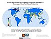
To identify spatial variations in the amount of NPP consumption relative to local production in a way that highlight humanity's growing impact on the biosphere. |
HANPP by Country and Product, v1 (1995)Human Appropriation of Net Primary Productivity (HANPP)To provide tabular data on human appropriation of net primary productivity by country. |
|
Environmental Vulnerability Index (EVI), 2004 Release (
|
Global Human Footprint (Geographic), v1 (
|
|
Top One Percent Wild Areas (IGHP), v1 (
|
Global Human Footprint (IGHP), v1 (
|
|
Last of the Wild (IGHP), v1 (
|
Top One Percent Wild Areas (Geographic), v1 (
|
|
Last of the Wild (Geographic), v1 (
|
Country-Level GDP and Downscaled Projections Based on the SRES A1, A2, B1, and B2 Marker Scenarios, v1 (
|
|
Country-Level Population and Downscaled Projections Based on the SRES B2 Scenario, v1 (
|
Country-Level Population and Downscaled Projections Based on the SRES A1, B1, and A2 Scenarios, v1 (
|
|
Population, Landscape, And Climate Estimates (PLACE), v1 (1995)National Aggregates of Geospatial Data Collection (NAGDC)To provide tabular data on environmental conditions (elevations, climate, coastal) in which people reside. |
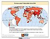
Environmental Sustainability Index, 2002 Release (
|
|
Rio to Johannesburg Dashboard of Sustainable Indicators, v1 (
|
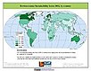
Environmental Sustainability Index, 2001 Release (
|
| 13 of 15 |