Data Sets (86)
| 3 of 5 |
Urban Extents Grid, v1 (1995)Global Rural-Urban Mapping Project (GRUMP), v1
To provide a raster representation of urban areas (or urban mask) for use with GRUMP population grids or other data sets. |
Land and Geographic Unit Area Grids, v1 (2000)Global Rural-Urban Mapping Project (GRUMP), v1To provide land area data for use with GRUMPv1 population and urban data as well as a quantitative measure of resolution of the input spatial units for GRUMPv1. |
|
Population Density Grid, v1 (1990, 1995, 2000)Global Rural-Urban Mapping Project (GRUMP), v1
To provide a time series of raster population density data for data integration. |
National Administrative Boundaries, v1 (2000)Global Rural-Urban Mapping Project (GRUMP), v1To permit cartographic display of countries and territories that exactly match the GRUMPv1 population surfaces |
|
Settlement Points, v1 (1990, 1995, 2000)Global Rural-Urban Mapping Project (GRUMP), v1
To provide populated place (point) data with consistent population estimates. |
Coastlines, v1 (2000)Global Rural-Urban Mapping Project (GRUMP), v1To permit cartographic display of coastlines that exactly match the GRUMPv1 population surfaces. |
|
National Identifier Grid, v1 (1995, 2000, 2010)Global Rural-Urban Mapping Project (GRUMP), v1To permit the summation of population values by country/territory and, in combination with other data layers, the summation of population values by irregular areas represented in the other data layers and country/territory. |
Natural Resource Management Index, 2010 Release (
|
|
Environmental Performance Index, 2010 Release (
|
CODATA Catalog of Roads, v1 (
|
|
Environmental Performance Index, 2008 Release (
|
||
Population, Landscape, And Climate Estimates (PLACE), v2 (1990, 2000)National Aggregates of Geospatial Data Collection (NAGDC)
To provide tabular data on environmental conditions (elevations, climate, coastal) in which people reside. |
Urban-Rural Population Estimates, v1 (1990, 1995, 2000)Low Elevation Coastal Zone (LECZ)
To provide estimates of urban and rural populations and land areas in the low elevation coastal zone. |
|
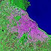
Urban Landsat: Cities from Space, v1 (
|
Synthetic Assessment of Global Distribution of Vulnerability to Climate Change, v1 (2005, 2050, 2100)Intergovernmental Panel on Climate Change
To provide geographical portraits of vulnerability designed to incorporate both exposure to climate change and national capacities to adapt. |
|
Pilot Environmental Performance Index, 2006 Release (
|
Complete Collection, v1.01 (
|
|
National Footprint Accounts, 2006 Release (2003)Compendium of Environmental Sustainability IndicatorsTo help assess a country's demand on and supply of biological capital. |
Ancillary Data, v1 (
|
| 3 of 5 |